 Filter: Categories of Wisconsin Historical Images
Filter: Subject of Ocean
Filter: Subject of political science
Filter: Subject of islands
Filter: Categories of Wisconsin Historical Images
Filter: Subject of Ocean
Filter: Subject of political science
Filter: Subject of islands

| Date: | 1945 |
|---|---|
| Description: | Marines use an International TD-9 crawler tractor (TracTracTor) with a dozer shovel loader to fill a truck parked on a beach. A ship is in the water behind... |

| Date: | |
|---|---|
| Description: | Etching of the "Attack upon Roanoke Island" by troops landing from naval vessels, after a painting by Chappel. |

| Date: | 1959 |
|---|---|
| Description: | Aerial view of the island of Cuba taken from a small plane. Part of the plane with a Cuban flag painted on it is in the frame, and the island with many bui... |

| Date: | 1712 |
|---|---|
| Description: | Engraved double-hemispherical world map by Moll, included in his atlas The world described, or, A new and correct sett of maps: shewing the kingdoms and st... |

| Date: | 1740 |
|---|---|
| Description: | Engraved and hand-colored map of the Iberian peninsula as a theater of war during the War of the Spanish Succession (1701-1714). The map is dedicated to Ki... |
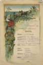
| Date: | 08 09 1890 |
|---|---|
| Description: | One-page menu from the R.M.S.S. Magdalena of the Royal Mail Steam Packet Company, with a parrot and a cockatiel perched on a branch above the compan... |

| Date: | 1733 |
|---|---|
| Description: | This map of North America shows settlements, rivers, lakes, Native American land, trade winds, and numerous topographical features such as forests and moun... |

| Date: | 1770 |
|---|---|
| Description: | Map of North America from the Great Lakes to the northern portion of South America. It shows cities, Native American land, mountains, swamps, lakes, rivers... |

| Date: | 1853 |
|---|---|
| Description: | A map of Wellfleet Harbor on Cape Cod Bay. |
If you didn't find the material you searched for, our Library Reference Staff can help.
Call our reference desk at 608-264-6535 or email us at: