 Filter: Categories of Wisconsin Historical Images
Filter: Subject of Ocean
Filter: Subject of men
Filter: Subject of cities and towns
Filter: Categories of Wisconsin Historical Images
Filter: Subject of Ocean
Filter: Subject of men
Filter: Subject of cities and towns
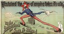
| Date: | 1886 |
|---|---|
| Description: | Advertisement for the Atchison, Topeka and Santa Fe Railroad featuring an illustration of Uncle Sam stretched from the Missouri River to the Pacific Ocean.... |
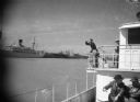
| Date: | |
|---|---|
| Description: | Bloch on a ship in Mississippi at New Orleans, headed for Baton Rouge. Trip was gratis from Victor Ehr, director of the Baton Rouge chamber of commerce and... |
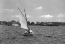
| Date: | |
|---|---|
| Description: | View across water toward people on a small sailboat on Barnegat Bay, and boathouses and buildings on the far shoreline. |

| Date: | |
|---|---|
| Description: | View of Plymouth Street looking towards the waterfront with large trees along the sidewalks. |
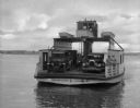
| Date: | |
|---|---|
| Description: | View of an automobile ferry boat traveling to or from Shelter Island Heights. Several men are on the ferry, along with three automobiles. "Shelter Island O... |

| Date: | 1968 |
|---|---|
| Description: | A man walking with a cane in the sand dunes on Coney Island. A dilapidated fence cuts across the foreground of the beach and a rock jetty juts into the ba... |
| Date: | 1910 |
|---|---|
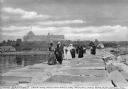
| Description: | A group of adults, mostly women, walk along the Rockland Breakwater. The Samoset Resort is in the background on the shoreline. Caption reads: "The Samoset ... |

| Date: | 02 05 1944 |
|---|---|
| Description: | General view of Port Moresby Harbor from road, New Guinea (present day Papua New Guinea). A jeep is on the road on the left. Several soldiers are near a sh... |

| Date: | 1712 |
|---|---|
| Description: | Engraved double-hemispherical world map by Moll, included in his atlas The world described, or, A new and correct sett of maps: shewing the kingdoms and st... |
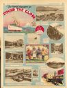
| Date: | 11 23 1930 |
|---|---|
| Description: | Full page illustrated article in the Milwaukee Journal titled "The World Voyagers go Round The Globe by Radio and Roto." Included are photographs an... |

| Date: | 1735 |
|---|---|
| Description: | A map of the western hemisphere, including parts of western Europe and Africa. Portraits of explorers, such as Jacques Marquette, Louis Joliet, and Robert ... |

| Date: | 1703 |
|---|---|
| Description: | Map of the Golf of Mexico and surrounding countries from the Great Lakes down to the northern most parts of South America. L'Isle labels cities, towns, and... |

| Date: | 1715 |
|---|---|
| Description: | One of Herman Moll's most famous maps, often referred to as The Codfish Map, it shows rivers and portages, cities, Indian villages, wind directions, routes... |

| Date: | 1780 |
|---|---|
| Description: | This map shows the northern Pacific Ocean with North America and Asia, with cities and geographical features labeled, as well Russian, French and Spanish r... |

| Date: | 1746 |
|---|---|
| Description: | This world map from the German mathematician, historian, and geographer Johann Matthias Hase shows the major cities, islands, and the major political divis... |

| Date: | 1627 |
|---|---|
| Description: | Map of North and South America showing settlements, rivers, lakes, mountains, islands and regions of the western hemisphere. It includes an inset map of Gr... |

| Date: | 1630 |
|---|---|
| Description: | One of the few maps by Dutch cartographer Willem Blaeu depicting the Americas, this map shows regions, settlements, islands, mountains, forests, rivers, an... |

| Date: | 1690 |
|---|---|
| Description: | A mysterious mixture of mythology, ancient geography, and late 17th century knowledge of the American coastline. This map shows North and South America, bu... |

| Date: | 1676 |
|---|---|
| Description: | Detailed map of North and South America. Cities, towns, forests, and mountains are shown pictorially. Duval labels regions, islands, cities, lakes, and Nat... |

| Date: | 1746 |
|---|---|
| Description: | Detailed map of the western hemisphere and part of Africa and Europe. Islands, cities, settlements, rivers, lakes, countries, and regions are marked. Mount... |
If you didn't find the material you searched for, our Library Reference Staff can help.
Call our reference desk at 608-264-6535 or email us at: