 Filter: Categories of Wisconsin Historical Images
Filter: Subject of Ocean
Filter: Subject of intellectual life
Filter: Subject of agriculture
Filter: Categories of Wisconsin Historical Images
Filter: Subject of Ocean
Filter: Subject of intellectual life
Filter: Subject of agriculture
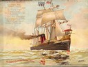
| Date: | 1897 |
|---|---|
| Description: | Color lithograph cover illustration for the McCormick Harvesting Machine Company catalog. Shows a steam powered sailing ship named "Progress" with a McCorm... |

| Date: | 1893 |
|---|---|
| Description: | Front and back covers of an advertising brochure for the New Empire line of mowers, reapers and grain binders manufactured by J.F. Seiberling & Company. Th... |

| Date: | 1938 |
|---|---|
| Description: | A colorful pictorial map of Australia, featured on the front and back cover of a special Australian edition of International Trail. |
| Date: | |
|---|---|
| Description: | Letterhead of the Ocean Spray brand of cranberries, with a can of jellied cranberry sauce and a serving dish with the sauce retaining the shape of its can ... |

| Date: | 1952 |
|---|---|
| Description: | Map of the barley-growing regions of North America, published by the Rahr Malting Company, Manitowoc, Wisconsin, 1952. |

| Date: | |
|---|---|
| Description: | Front cover and partial menu listing with drinks overleaf. Front cover has a porthole view of pairs of men in three boats with mountains and palm trees in ... |

| Date: | 1946 |
|---|---|
| Description: | This bird's-eye-view map shows scenes of land use and farming superimposed on a map of the United States. Agricultural scenes of farming, livestock, and cr... |

| Date: | 1942 |
|---|---|
| Description: | This pictorial bird's-eye-view map shows the United States of America with parts of Canada and Mexico. Landscape, trade, industry, points of interest, peop... |

| Date: | 1780 |
|---|---|
| Description: | This map shows the townships, parishes, cities, towns, plantations, lakes, rivers, swamps, and roads near the coast of South Carolina and Georgia. Emphasis... |
If you didn't find the material you searched for, our Library Reference Staff can help.
Call our reference desk at 608-264-6535 or email us at: