 Filter: Categories of Wisconsin Historical Images
Filter: Subject of Ocean
Filter: Subject of industries
Filter: Categories of Wisconsin Historical Images
Filter: Subject of Ocean
Filter: Subject of industries
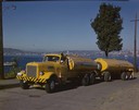
| Date: | 1951 |
|---|---|
| Description: | Color photograph of an International LD-400 series tanker truck owned by Eastern Washington Transports, Inc., on a road near the Port of Seattle. |

| Date: | 1920 |
|---|---|
| Description: | A view of Yorks Island Harbor and lobster fishing boats in a cove. Caption reads: "Lobster Fleet at Yorks Island Harbor, Isle au Haut, Me." |

| Date: | 1915 |
|---|---|
| Description: | Boats unloading at Standard Oil Co.'s pier, with a horse, wagon, and a number of men handling lumber and other building materials. |

| Date: | 1932 |
|---|---|
| Description: | Map of the Middle East accompanying an article on International's involvement in building the Iraq Pipe Line. Headline text on the page reads: "Internation... |
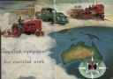
| Date: | 1955 |
|---|---|
| Description: | Men are driving International Harvester tractor, truck and crawler in a cloud above the continent of Australia. The IH logo is at the bottom right in a com... |
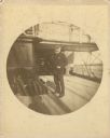
| Date: | 1891 |
|---|---|
| Description: | Frederick Layton standing on deck smoking a cigar while at sea in a Kodak #2 camera portrait by T.W. Ingersoll from St. Paul, Minnesota. The photographer's... |

| Date: | 1719 |
|---|---|
| Description: | Map of the British colonies and territories in North American, depicting cities, Native American land, rivers, mines, forts, trees, and topography east of ... |

| Date: | 1781 |
|---|---|
| Description: | Map of the Southeastern part of the British Colonies in North America, Gulf Coast and Caribbean. It illustrates the of the Spanish and English fleets, part... |

| Date: | 1911 |
|---|---|
| Description: | Map of states in the United States, as well as inset maps of Russia, France, Germany and Sweden. At bottom right is a key for the map that includes: a numb... |

| Date: | 1965 |
|---|---|
| Description: | Elevated view of the Biological Laboratory in Antarctica. |
If you didn't find the material you searched for, our Library Reference Staff can help.
Call our reference desk at 608-264-6535 or email us at: