 Filter: Categories of Wisconsin Historical Images
Filter: Subject of Ocean
Filter: Subject of cities and towns
Filter: Subject of dwellings
Filter: Categories of Wisconsin Historical Images
Filter: Subject of Ocean
Filter: Subject of cities and towns
Filter: Subject of dwellings
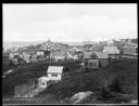
| Date: | 1920 |
|---|---|
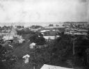
| Description: | Elevated view from hill looking down toward buildings in the hills along the coast. |

| Date: | |
|---|---|
| Description: | Elevated view of village homes on the shores of the bay with docked fishing boats in the foreground. Caption reads, "Marblehead, Mass from Rockmere Point." |
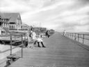
| Date: | |
|---|---|
| Description: | View down wide boardwalk, with a man and a young girl sitting on a boardwalk bench on the left. Several other people look out at the ocean from the railing... |
| Date: | 1920 |
|---|---|
| Description: | View along rocky shoreline towards adults and children on the seashore, nde wading in the water. In the distance are cottages and other buildings, possibly... |
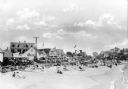
| Date: | 1910 |
|---|---|
| Description: | View along beach toward sunbathers sitting and walking along the seashore. A line of automobiles are parked alongside the beach, separated from the sand by... |
| Date: | |
|---|---|
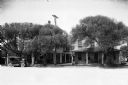
| Description: | View of oceanside residences along a town's main street. |
| Date: | |
|---|---|
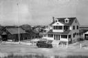
| Description: | View downhill towards a neighborhood crowded with cottages. |
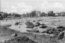
| Date: | |
|---|---|
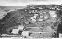
| Description: | Elevated view of an Eskimo tent village on sandspit along the shoreline. Wood buildings are along higher ground on the right near a river. |

| Date: | 02 05 1944 |
|---|---|
| Description: | General view of Port Moresby Harbor from road, New Guinea (present day Papua New Guinea). A jeep is on the road on the left. Several soldiers are near a sh... |
| Date: | 1902 |
|---|---|
| Description: | Elevated view of the city of Port Limon, Costa Rica with the Caribbean Sea in the background. Trees grow amongst the many commercial and residential buildi... |

| Date: | 1720 |
|---|---|
| Description: | This map of North America shows cities, rivers, lakes, and a few topographical features, complete with numerous descriptive blocks of text about expedition... |

| Date: | 1780 |
|---|---|
| Description: | This map shows the townships, parishes, cities, towns, plantations, lakes, rivers, swamps, and roads near the coast of South Carolina and Georgia. Emphasis... |
If you didn't find the material you searched for, our Library Reference Staff can help.
Call our reference desk at 608-264-6535 or email us at: