Filter: Categories of Wisconsin Historical Images
Filter: Subject of Neighborhoods
Filter: Year of 1800-1899
Filter: Year of 1860-1869
Filter: Categories of Wisconsin Historical Images
Filter: Subject of Neighborhoods
Filter: Year of 1800-1899
Filter: Year of 1860-1869
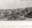
| Date: | 1862 |
|---|---|
| Description: | John S. Fuller took this image of the third Wisconsin State Capitol (the second in Madison), from Governor Farwell's Octagon House, probably early in 1862.... |
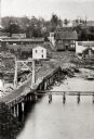
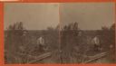
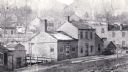
| Date: | 1865 |
|---|---|
| Description: | Elevated view of a bridge and logging debris around residential homes. |
| Date: | 1860 |
|---|---|
| Description: | Elevated view of the Janesville Countryside. |
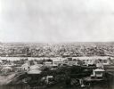
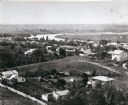
| Date: | 1860 |
|---|---|
| Description: | Elevated view of Janesville with a residential area in the foreground and the business district in the background. |
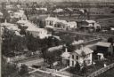
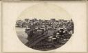
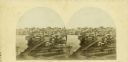
| Date: | 1865 |
|---|---|
| Description: | Aerial view of a residential part of Janesville. |
| Date: | 1865 |
|---|---|
| Description: | Stereograph elevated view of a home in Lancaster. |
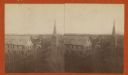
| Date: | 1865 |
|---|---|
| Description: | Stereograph view looking downhill towards Lancaster, with the Congregational Church to the right. |

| Date: | 1865 |
|---|---|
| Description: | Harvey Hospital, or the Soldiers' Orphans Home. The main octagon section was the home of Governor Farwell, and the wing of wood was added in 1862 and used ... |
| Date: | 1868 |
|---|---|
| Description: | Mineral Point from a carte-de-visite by the "practical photographer." |

| Date: | 1860 |
|---|---|
| Description: | View of St. John's Catherdral with the original tower. |
| Date: | 1862 |
|---|---|
| Description: | The third Wisconsin State Capitol (the second in Madison), from Governor Farwell's Octagon House, probably early in 1862. Also visible in the downtown are ... |
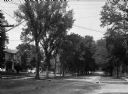
| Date: | 1860 |
|---|---|
| Description: | A view of a tree-lined residential street with houses partially visible on the left. |

| Date: | 1860 |
|---|---|
| Description: | Map shows meadows, forests, buildings, railroad, and lots south of part of the city of Milwaukee. Relief shown by hachures. Includes list of lot acreages. |

| Date: | 1863 |
|---|---|
| Description: | This map of Superior shows Montgomery's Addition. An inset map shows the south west end of Lake Superior where Montgomery's Addition is located. The map re... |

| Date: | 1868 |
|---|---|
| Description: | This map shows lot and block numbers, some property ownership, wards, roads, and railroads. An inset map shows the Glidden & Lockwood’s addition. There are... |

| Date: | 1869 |
|---|---|
| Description: | This map shows lot and block numbers, some property ownership, wards, roads, and railroads and includes inset map of Glidden & Lockwood’s addition. There a... |
If you didn't find the material you searched for, our Library Reference Staff can help.
Call our reference desk at 608-264-6535 or email us at: