Filter: Categories of Wisconsin Historical Images
Filter: Subject of Neighborhoods
Filter: Subject of landforms
Filter: Categories of Wisconsin Historical Images
Filter: Subject of Neighborhoods
Filter: Subject of landforms

| Date: | 11 19 1970 |
|---|---|
| Description: | Exterior view of the uniquely designed house of Byron Bloomfield at 1010 Edgehill Drive in Shorewood Hills, which is built into the side of a sharp slope. ... |

| Date: | 02 06 1948 |
|---|---|
| Description: | Aerial photograph of Madison's west side looking northeast along Speedway Road. Visible are Forest Hill and Resurrection Cemeteries, West High School, Hoyt... |

| Date: | 02 06 1948 |
|---|---|
| Description: | Aerial view of west side, looking south along Glenway Street. Visible are the reservoir, Lake Wingra, Forest Hill and Resurrection Cemetery, Hoyt Park. Maj... |

| Date: | 02 06 1948 |
|---|---|
| Description: | Aerial photograph looking northwest across the reservoir on Glenway Street. Featured are Hoyt and Quarry Parks, Resurrection Cemetery. Major streets are Fr... |

| Date: | 02 06 1948 |
|---|---|
| Description: | Looking north along Glenway Street. Visible are the reservoir, Hoyt and Quarry Parks, Resurrection and Forest Hill Cemeteries, Rentschler Greenhouses, Fore... |

| Date: | 02 06 1948 |
|---|---|
| Description: | Looking southeast across Speedway Road. Visible are the reservoir on Glenway Street, Hoyt Park, Resurrection and Forest Hill cemeteries, Glenway Golf cours... |

| Date: | 02 06 1948 |
|---|---|
| Description: | Looking east along Regent Street with snow on the ground. Visible are Lake Wingra, Monona Bay, railroad causeway across Monona, Lake Mendota, Hoyt Park, We... |

| Date: | 08 06 1948 |
|---|---|
| Description: | Elevated view of west side neighborhood showing East Hill Trailer Camp, 451 N. Midvale Boulevard, at the corner of University Avenue and Midvale Boulevard. |
| Date: | 08 06 1948 |
|---|---|
| Description: | Elevated view of west side neighborhood showing houses to the east of Midvale Boulevard. |
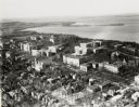
| Date: | 1924 |
|---|---|
| Description: | University of Wisconsin-Madison lower campus and the surrounding neighborhoods. Lake Mendota and Picnic Point are in the background. |
| Date: | 1924 |
|---|---|
| Description: | University of Wisconsin-Madison aerial view overlooking the lower campus and surrounding neighborhoods. Lake Mendota and Picnic Point are in the background... |
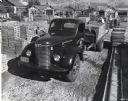
| Date: | 1948 |
|---|---|
| Description: | An International Model KB-7 truck used to transport concrete blocks parked on a work or storage site surrounded by building materials. A man loads concrete... |
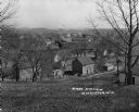
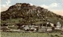
| Date: | |
|---|---|
| Description: | View of town taken from the top of a hill. |
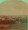
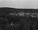
| Date: | 1885 |
|---|---|
| Description: | Stereograph view of Menomonie. A group of people sit on a hill in the foreground overlooking the town. |
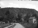
| Date: | |
|---|---|
| Description: | View down road towards houses with a rock formation in the distance. Children are walking on the sidewalk on the left. |

| Date: | 1963 |
|---|---|
| Description: | "The view south from St. Theresa Catholic Church." |

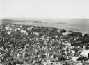
| Date: | |
|---|---|
| Description: | Elevated panoramic view of the city of Madison, with the Wisconsin State Capitol and Lake Monona on the far left, and Picnic Point and Lake Mendota on the ... |

| Date: | 1890 |
|---|---|
| Description: | Plat map of Madison, T7N R9E, including portions of the towns of Blooming Grove and Burke. Includes inset maps of South Madison, Quarrytown, Marril Park, a... |
If you didn't find the material you searched for, our Library Reference Staff can help.
Call our reference desk at 608-264-6535 or email us at: