 Filter: Categories of Wisconsin Historical Images
Filter: Subject of Municipal services
Filter: Year of 1900-1999
Filter: Categories of Wisconsin Historical Images
Filter: Subject of Municipal services
Filter: Year of 1900-1999
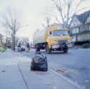
| Date: | 1976 |
|---|---|
| Description: | View down sidewalk of two African-American sanitation workers carrying cans and sacks of trash to a garbage truck, is stopped in a residential neighborhood... |

| Date: | 1973 |
|---|---|
| Description: | View from lawn in a residential neighborhood of three men pushing trash cans on hand carts towards a garbage truck. Behind the garbage truck is an Internat... |

| Date: | 1973 |
|---|---|
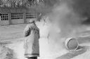
| Description: | An African-American man is dumping a barrel of trash into an International Harvester Scout with a dump body driven by another African-American man. They ar... |
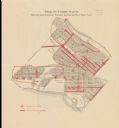
| Date: | 1916 |
|---|---|
| Description: | Shows streetlights, streets improvements, and sewer districts in red. Points of interest are labelled. Map reads: "Map of Tenth Ward Showing Improvements S... |

| Date: | 1903 |
|---|---|
| Description: | This map is ink on printed paper reading: "standard profile plate." "Surveyed Oct. 15, platted Dec. 15, 1903 ; surveyed May 9, platted Dec. 9." |

| Date: | 1908 |
|---|---|
| Description: | Shows pipes of various sizes, hydrants, valves, and wells. "1907" -- Lower margin. Lake Wingra, Lake Monona, and Lake Mendota are labelled. |
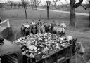
| Date: | 04 17 1959 |
|---|---|
| Description: | Thirty-three Sun Prairie 4-H youngsters are shown with one of four truckloads of trash they picked up along area highways. |

| Date: | 11 11 1959 |
|---|---|
| Description: | Portrait of Dane County highway commissioner, Ray R. Swann. |

| Date: | 01 14 1960 |
|---|---|
| Description: | Madison Fire Chief Edward Page, center, presents a plaque from the International Fire Chiefs Association to Maple Bluff's volunteer fire department for ach... |

| Date: | 02 02 1960 |
|---|---|
| Description: | The Madison Redevelopment Authority joined in the city's program of locating and permanently marking land survey corners in the Madison area. Here they mar... |
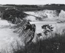
| Date: | 1963 |
|---|---|
| Description: | Sand and gravel pit used by the Dane County highway department as a source of supply. |

| Date: | 11 12 1960 |
|---|---|
| Description: | A scene from a fire school held by the Maple bluff fire department for their volunteer firemen. They witnessed demonstrations on how to put out different t... |
| Date: | 11 12 1960 |
|---|---|
| Description: | A scene from a fire school held by the Maple bluff fire department for their volunteer firemen. They witnessed demonstrations on how to put out different t... |

| Date: | 1920 |
|---|---|
| Description: | This map shows a plat of the area, numbered blocks and lots, local streets, roads, parks, Nakoma Country Club golf course, and landscaping. The map is orie... |
| Date: | 1920 |
|---|---|
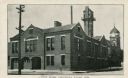
| Description: | View from street of Chippewa Falls city hall. On the left are garage doors for fire engine storage, and a watch tower is at upper right. Another building ... |
| Date: | 05 15 1931 |
|---|---|
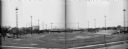
| Description: | Composite of two negatives of Breese Stevens Athletic Field with lights on tall poles. On the left, view is of the Simon Brothers Wholesale Grocery Warehou... |

| Date: | 1910 |
|---|---|
| Description: | This maps is pen and pencil on tracing cloth and shows local streets, buildings, proposed and present branches of railroad track, and sewer and water lines... |

| Date: | 03 1964 |
|---|---|
| Description: | This map shows lot and block numbers, some landownership, disposal plant and pumping station, streets, parks, and vacated land. Lake Delton and streets are... |

| Date: | 1960 |
|---|---|
| Description: | This blue line print map shows pipes, valves, well site, and elevation tank, as well as lot and block numbers and dimensions. The map includes inset of con... |
| Date: | 04 1958 |
|---|---|
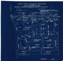
| Description: | This blueprint map shows additions, sections, and streets. The upper left of the map reads: "Plan for 6ʺ watermain, hydrants & appurtenances." The up... |
If you didn't find the material you searched for, our Library Reference Staff can help.
Call our reference desk at 608-264-6535 or email us at: