 Filter: Categories of Wisconsin Historical Images
Filter: Subject of Municipal services
Filter: Subject of cities and towns
Filter: Categories of Wisconsin Historical Images
Filter: Subject of Municipal services
Filter: Subject of cities and towns

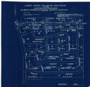
| Date: | 1896 |
|---|---|
| Description: | Shows pipes of various sizes, hydrants with hydrant pressure, valves, wells, projected lines, and suction pipes. Differs from earlier versions by inclusion... |

| Date: | 1903 |
|---|---|
| Description: | This map is ink on printed paper reading: "standard profile plate." "Surveyed Oct. 15, platted Dec. 15, 1903 ; surveyed May 9, platted Dec. 9." |

| Date: | 1908 |
|---|---|
| Description: | Shows pipes of various sizes, hydrants, valves, and wells. "1907" -- Lower margin. Lake Wingra, Lake Monona, and Lake Mendota are labelled. |

| Date: | 02 02 1960 |
|---|---|
| Description: | The Madison Redevelopment Authority joined in the city's program of locating and permanently marking land survey corners in the Madison area. Here they mar... |

| Date: | 1894 |
|---|---|
| Description: | This map shows lot and block numbers, railroads, street car tracks, sewers, water mains, gas mains, paved streets, land owned by the Land & River Improveme... |

| Date: | 1920 |
|---|---|
| Description: | This map shows a plat of the area, numbered blocks and lots, local streets, roads, parks, Nakoma Country Club golf course, and landscaping. The map is orie... |
| Date: | 1920 |
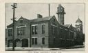
|---|---|
| Description: | View from street of Chippewa Falls city hall. On the left are garage doors for fire engine storage, and a watch tower is at upper right. Another building ... |
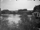
| Date: | |
|---|---|
| Description: | Elevated view towards high water in a town. Location identified looking west from the German Hill bridge in Black River Falls. The high water is from a flo... |
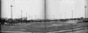
| Date: | 05 15 1931 |
|---|---|
| Description: | Composite of two negatives of Breese Stevens Athletic Field with lights on tall poles. On the left, view is of the Simon Brothers Wholesale Grocery Warehou... |

| Date: | 1910 |
|---|---|
| Description: | This maps is pen and pencil on tracing cloth and shows local streets, buildings, proposed and present branches of railroad track, and sewer and water lines... |

| Date: | 1892 |
|---|---|
| Description: | This map shows water pipes, hydrants, stop cocks, check valves, fire cysterns, and manholes. Also shown are block numbers, streets, railroads, parks, cemet... |

| Date: | 03 1964 |
|---|---|
| Description: | This map shows lot and block numbers, some landownership, disposal plant and pumping station, streets, parks, and vacated land. Lake Delton and streets are... |

| Date: | 1960 |
|---|---|
| Description: | This blue line print map shows pipes, valves, well site, and elevation tank, as well as lot and block numbers and dimensions. The map includes inset of con... |

| Date: | 1894 |
|---|---|
| Description: | This map shows sewers, intercepting sewers, manholes, block numbers, streets, railroads, parks, cemeteries, and Lake Michigan. The right margin reads: "Tot... |

| Date: | 1887 |
|---|---|
| Description: | This map shows sewers, manholes, streets, canals, rivers, and Lake Michigan. An explanation of sewer types is included. |
| Date: | 04 1958 |
|---|---|
| Description: | This blueprint map shows additions, sections, and streets. The upper left of the map reads: "Plan for 6ʺ watermain, hydrants & appurtenances." The up... |

| Date: | 1940 |
|---|---|
| Description: | This map hows block and lot numbers, water mains, roads, parks, the Sheboygan River and some landownership. |

| Date: | 12 1912 |
|---|---|
| Description: | Sanborn map of Sun Prairie, which includes an index and information about water facilities and the fire department. Includes a small inset map of the State... |
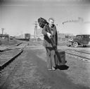
| Date: | 1940 |
|---|---|
| Description: | A photographer is walking near railroad tracks at a railroad crossing, with an automobile at the crossing in the background on the right. The photographer ... |
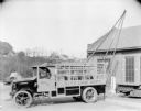
| Date: | 12 16 1926 |
|---|---|
| Description: | A man is sitting in the driver's seat of a truck. On the side of the truck is a sign that reads: "City Line Dep't." Equipment is hanging in the back of the... |
If you didn't find the material you searched for, our Library Reference Staff can help.
Call our reference desk at 608-264-6535 or email us at: