 Filter: Categories of Wisconsin Historical Images
Filter: Subject of Municipal services
Filter: County of Dane
Filter: Categories of Wisconsin Historical Images
Filter: Subject of Municipal services
Filter: County of Dane

| Date: | 10 25 1957 |
|---|---|
| Description: | Six officials pose for a group portrait at the dedication of a playground structure made of concrete in the shape of a castle; it is sponsored by the Jayce... |

| Date: | 03 14 1958 |
|---|---|
| Description: | Elevated view of 13 firemen sitting at two tables, ready to eat their 11 am meal. The men are at Central Station at 18 South Webster Street. From left to ... |
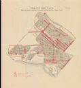
| Date: | 1916 |
|---|---|
| Description: | Shows streetlights, streets improvements, and sewer districts in red. Points of interest are labelled. Map reads: "Map of Tenth Ward Showing Improvements S... |

| Date: | 1880 |
|---|---|
| Description: | This map is pen-and-ink on paper. The map shows buildings, trees, and water and gas pipes, relief is shown by contours. The back of the map reads: "Univers... |

| Date: | 1887 |
|---|---|
| Description: | Shows pipes of various sizes, hydrants with hydrant pressure, valves, wells, and projected lines. |

| Date: | 1892 |
|---|---|
| Description: | Shows pipes of various sizes, hydrants with hydrant pressure, valves, wells, and projected lines. Differs from earlier versions by inclusion of Wingra Park... |

| Date: | 1896 |
|---|---|
| Description: | Shows pipes of various sizes, hydrants with hydrant pressure, valves, wells, projected lines, and suction pipes. Differs from earlier versions by inclusion... |

| Date: | 1903 |
|---|---|
| Description: | This map is ink on printed paper reading: "standard profile plate." "Surveyed Oct. 15, platted Dec. 15, 1903 ; surveyed May 9, platted Dec. 9." |

| Date: | 1908 |
|---|---|
| Description: | Shows pipes of various sizes, hydrants, valves, and wells. "1907" -- Lower margin. Lake Wingra, Lake Monona, and Lake Mendota are labelled. |
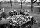
| Date: | 04 17 1959 |
|---|---|
| Description: | Thirty-three Sun Prairie 4-H youngsters are shown with one of four truckloads of trash they picked up along area highways. |

| Date: | 11 11 1959 |
|---|---|
| Description: | Portrait of Dane County highway commissioner, Ray R. Swann. |

| Date: | 01 14 1960 |
|---|---|
| Description: | Madison Fire Chief Edward Page, center, presents a plaque from the International Fire Chiefs Association to Maple Bluff's volunteer fire department for ach... |

| Date: | 02 02 1960 |
|---|---|
| Description: | The Madison Redevelopment Authority joined in the city's program of locating and permanently marking land survey corners in the Madison area. Here they mar... |
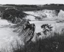
| Date: | 1963 |
|---|---|
| Description: | Sand and gravel pit used by the Dane County highway department as a source of supply. |

| Date: | 11 12 1960 |
|---|---|
| Description: | A scene from a fire school held by the Maple bluff fire department for their volunteer firemen. They witnessed demonstrations on how to put out different t... |

| Date: | 11 12 1960 |
|---|---|
| Description: | A scene from a fire school held by the Maple bluff fire department for their volunteer firemen. They witnessed demonstrations on how to put out different t... |

| Date: | 1920 |
|---|---|
| Description: | This map shows a plat of the area, numbered blocks and lots, local streets, roads, parks, Nakoma Country Club golf course, and landscaping. The map is orie... |

| Date: | 1910 |
|---|---|
| Description: | This maps is pen and pencil on tracing cloth and shows local streets, buildings, proposed and present branches of railroad track, and sewer and water lines... |

| Date: | 12 1912 |
|---|---|
| Description: | Sanborn map of Sun Prairie, which includes an index and information about water facilities and the fire department. Includes a small inset map of the State... |

| Date: | 12 2013 |
|---|---|
| Description: | A cherry-picker is lifting a line worker holding a STIHL chainsaw and wearing a helmet high in the air next to a Siberian elm that is in the process of bei... |
If you didn't find the material you searched for, our Library Reference Staff can help.
Call our reference desk at 608-264-6535 or email us at: