 Filter: Categories of Wisconsin Historical Images
Filter: Subject of Mountains
Filter: Subject of transportation
Filter: Year of 1800-1899
Filter: Categories of Wisconsin Historical Images
Filter: Subject of Mountains
Filter: Subject of transportation
Filter: Year of 1800-1899
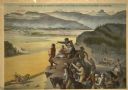
| Date: | 1886 |
|---|---|
| Description: | Advertising poster showing color illustration of pioneers on a bluff overlooking a McCormick binder harvesting grain in the valley below. The poster bears ... |

| Date: | 1850 |
|---|---|
| Description: | Pic Island on the north shore of Lake Superior. |

| Date: | 02 21 1874 |
|---|---|
| Description: | African American boatmen run a rapids in a small river boat. |

| Date: | 1893 |
|---|---|
| Description: | Front and back covers of an advertising brochure for the New Empire line of mowers, reapers and grain binders manufactured by J.F. Seiberling & Company. Th... |
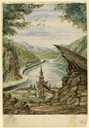
| Date: | 1857 |
|---|---|
| Description: | Business with Frank Leslie's Illustrated Newspaper took Hölzlhuber to New York, and from there he also visited Philadelphia, Baltimore, and Washingt... |

| Date: | 1858 |
|---|---|
| Description: | Hölzlhuber traveled on American railways frequently and marveled that they wouldn't have been accepted as usable in Europe. This sketch of the tunnel on th... |
| Date: | 06 30 1849 |
|---|---|
| Description: | The Black Hills sketched by Wilkins on his 151-day journey from Missouri to California on the Overland Trail (also known as the Oregon Trail). |
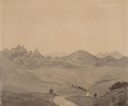
| Date: | 07 12 1849 |
|---|---|
| Description: | Wilkins' first sighting of the Rocky Mountains; sketched by Wilkins on his 151-day journey from Missouri to California on the Overland Trail (also known as... |
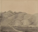
| Date: | 08 01 1849 |
|---|---|
| Description: | Bear Valley in Utah with a wagon train descending the mountains. sketched by Wilkins on his 151-day journey from Missouri to California on the Overland Tra... |
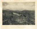
| Date: | 1866 |
|---|---|
| Description: | View towards the Allatoona Pass from behind earthworks overlooking the Etawah River. A railroad bridge crosses the river on the right. Plate 24 |

| Date: | 1866 |
|---|---|
| Description: | View along earthworks overlooking the Etawah River and a railroad bridge. A tree stripped of branches and bark is on the left. Plate 23 |
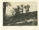
| Date: | 1866 |
|---|---|
| Description: | A road runs up the side of Mission Ridge with several trees. Trees and shrubs are in the foreground, overlooking a valley. Mountains are in the distance. |
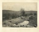
| Date: | 1866 |
|---|---|
| Description: | A rocky ridge with bushes and scrub atop Mission Ridge is in the foreground. Orchard Knob is in the distance. The valley where the fighting took place is i... |
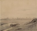
| Date: | 1866 |
|---|---|
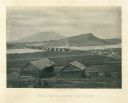
| Description: | Two log buildings are in the foreground. A bridge spans a river in the middle distance, and the city of Chattanooga is on the far side at the base of a mou... |
| Date: | 1864 |
|---|---|
| Description: | Union soldiers stand by their tents in front of a trestle bridge on the railroad line that spans a valley. A mountain is in the background. Plate 06 |

| Date: | 1864 |
|---|---|
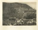
| Description: | View down to valley of Union soldiers posing on the roof of a log building. A log bridge crosses a stream, and many trees are on the hillsides. Plate 05... |

| Date: | 1862 |
|---|---|
| Description: | This map of the southeastern United States shows cities and towns, rail lines, and geographic features such as rivers, mountains, lakes, and swamps. |

| Date: | 02 1823 |
|---|---|
| Description: | A map featuring the North American expedition from Pittsburgh to the Rocky Mountains led by Edwin James. |
| Date: | 08 09 1879 |
|---|---|
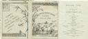
| Description: | Dinner menu from the Steamer Japan of the Lake Superior Transit Company, with a panel including a stalk of bamboo, a dragonfly, and a butterfly, and... |

| Date: | 08 1892 |
|---|---|
| Description: | Engraving, probably after a photograph, showing Frank Lenz posing with his safety bicycle near the stone arch entrance of a canal tunnel cut through a moun... |
If you didn't find the material you searched for, our Library Reference Staff can help.
Call our reference desk at 608-264-6535 or email us at: