 Filter: Categories of Wisconsin Historical Images
Filter: Subject of Monuments
Filter: Year of 1800-1899
Filter: Categories of Wisconsin Historical Images
Filter: Subject of Monuments
Filter: Year of 1800-1899
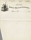
| Date: | 1880 |
|---|---|
| Description: | Letterhead with an illustration of a soldier on guard duty in camp and the name of the associations' officers. |

| Date: | 1851 |
|---|---|
| Description: | A view of campus green space at Ripon College. A commemorative stone marker in the foreground has text that reads: "Rendezvous 1st Wis. Cav. Aug. 15 to Nov... |

| Date: | 1867 |
|---|---|
| Description: | View across lawn toward a campus building at Ripon College. A stone commemorative marker is on the lawn on the right. Caption reads: "Scene, Ripon College,... |
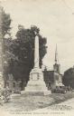
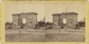
| Date: | 11 01 1875 |
|---|---|
| Description: | Erected in Girard, Pennsylvania, in 1875 to the memory of soldiers in the Civil War. Likeness of "Old Abe" appears on the top of the monument. On the botto... |
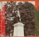
| Date: | 1870 |
|---|---|
| Description: | A stereograph of a statue of Thomas J. "Stonewall" Jackson. |
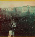
| Date: | 04 20 1861 |
|---|---|
| Description: | Elevated stereograph view of the Great Union Meeting at the New York City Union Square. |

| Date: | 1898 |
|---|---|
| Description: | Four girls are each standing behind a child sitting in a stroller while posing around Lewis Fountain in Veteran's Park. Houses and the Civil War Veteran's ... |
| Date: | 07 1863 |
|---|---|
| Description: | Stereograph of the Evergreen Cemetery, a private cemetery in Gettysburg opened in 1855. Because of its location on Cemetery Hill, the highest point in the ... |

| Date: | 1882 |
|---|---|
| Description: | Plat map of the village of Dunbarton, received by the Lafayette County Register's Office on September 22, 1892. Certification by the surveyor, Albert Pool,... |
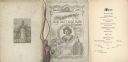
| Date: | 02 22 1892 |
|---|---|
| Description: | Back cover, front cover, and menu page for the Old Settlers' Club of Milwaukee County annual banquet. The back page includes an illustration of a monument ... |

| Date: | 1861 |
|---|---|
| Description: | This map shows lot and block numbers, piers, streets, monuments, and township section corners. Included is a note on the width of avenues, piers, slips, al... |

| Date: | 06 1845 |
|---|---|
| Description: | This map is pen-and-ink on paper and shows the numbers, dimensions, and acreages of lots, as well as survey monuments and streets. Also included is a certi... |

| Date: | 1872 |
|---|---|
| Description: | This map shows wards, roads, railroads, lot and block numbers, subdivisions, parks, some landownership, and a race course. Manuscript annotations in red in... |

| Date: | 1879 |
|---|---|
| Description: | This map shows wards, sections, roads, lot and block numbers, subdivisions, and proposed streets. The inside cover includes hand written annotations that r... |

| Date: | 1880 |
|---|---|
| Description: | This map shows wards, roads, railroads, lot and block numbers, subdivisions, parks, and some landownership. A handwritten annotation in red reads: "Note: S... |
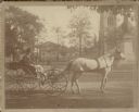
| Date: | 1890 |
|---|---|
| Description: | A light-colored horse is hitched to a small buggy driven by Lester Carr. Carr is wearing a hat and has a lap robe across his legs. The buggy is stopped on ... |
If you didn't find the material you searched for, our Library Reference Staff can help.
Call our reference desk at 608-264-6535 or email us at: