 Filter: Categories of Wisconsin Historical Images
Filter: Subject of Mississippi River
Filter: Year of 1800-1899
Filter: Year of 1840-1849
Filter: Categories of Wisconsin Historical Images
Filter: Subject of Mississippi River
Filter: Year of 1800-1899
Filter: Year of 1840-1849

| Date: | 1848 |
|---|---|
| Description: | In 1849, northern Wisconsin was composed of huge sectional regions such as Chippewa, Portage, Brown and Crawford, whereas southern Wisconsin was constitute... |
| Date: | 1840 |
|---|---|
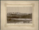
| Description: | Photograph of a painting of the second Fort Crawford, built 1829-1835. Two men are in a boat in the water in the foreground. The first Fort Crawford at Pra... |

| Date: | 1848 |
|---|---|
| Description: | The first Fort Crawford at Prairie du Chien, with the Mississippi River in the foreground. Although dated 1830, this scene was actually painted by Henry Le... |

| Date: | 1840 |
|---|---|
| Description: | Fort Crawford (the second site, with buildings of 1829-?), on the east bank of the Mississippi River, about 2 miles above the mouth of the Wisconsin River. |

| Date: | 1842 |
|---|---|
| Description: | A map of the Western rivers, a "travellers guide" exhibiting the Mississippi, Missouri, Ohio and Illinois Rivers with principal towns. |

| Date: | 1844 |
|---|---|
| Description: | A hand-colored map and chart showing a geological cross-section from Rockingham, in present-day Scott County, Iowa, through Blue Mounds to the Wisconsin Ri... |

| Date: | 1849 |
|---|---|
| Description: | Published in Germany a year after Wisconsin entered statehood, this map shows prairies, swamps, lakes, mounds, limestone deposits, and lead and copper mine... |

| Date: | 1846 |
|---|---|
| Description: | This map shows rivers, lakes, and towns in states west of the Mississippi River. Lake Michigan, Lake Superior, and Green Bay are labeled. Some areas are ou... |

| Date: | 1847 |
|---|---|
| Description: | This hand-colored map shows area north and west of Wisconsin River and south and east of Saint Louis and upper Mississippi Rivers. |

| Date: | 1845 |
|---|---|
| Description: | Map of Wisconsin, including lower western border with Iowa, southern border along Illinois, eastern shoreline of Lake Michigan, and northern area along Wis... |
If you didn't find the material you searched for, our Library Reference Staff can help.
Call our reference desk at 608-264-6535 or email us at: