 Filter: Categories of Wisconsin Historical Images
Filter: Subject of Mississippi River
Filter: Year of 1800-1899
Filter: Categories of Wisconsin Historical Images
Filter: Subject of Mississippi River
Filter: Year of 1800-1899
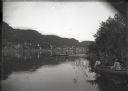
| Date: | 1890 |
|---|---|
| Description: | Oblique view from the Mississippi River. Two young women are in a rowboat near the shoreline, and two young men are fishing in the river. Alma at the foot ... |
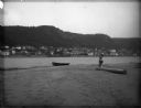
| Date: | 1890 |
|---|---|
| Description: | View of Alma across river from sandbar. A rowboat is on the sandbar, and on the right a father and child are standing posed each with one foot on a log. |
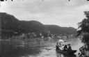
| Date: | 1885 |
|---|---|
| Description: | Four men and one woman in a rowboat on the Mississippi River. In the background is the town of Alma at the foot of bluffs. The woman is holding an umbrella... |

| Date: | 1895 |
|---|---|
| Description: | Christmas postcard of four men and one woman in a rowboat on the Mississippi River. In the background is the town of Alma at the foot of bluffs. The woman ... |
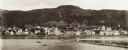
| Date: | 1897 |
|---|---|
| Description: | View of Alma from the Mississippi River, with wing dam on right. |

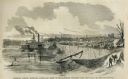
| Date: | 1862 |
|---|---|
| Description: | Elevated view of Vicksburg, with the Mississippi River in the background. |

| Date: | 1878 |
|---|---|
| Description: | Illustrated map of Crawford County. On the bottom right is an inset of a group of people near a train on a railroad track. |
| Date: | 05 31 1862 |
|---|---|
| Description: | Engraved view of the Commisary [sic] depot of Major-General Halleck's army at Hamburg Landing. |
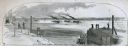
| Date: | 04 05 1862 |
|---|---|
| Description: | Engraved illustration for the story titled: "The Fight at Island No. 10". The view from the deck of a boat looks out at the approaching gun boats coming do... |

| Date: | 1880 |
|---|---|
| Description: | Stereograph of the Artesian Well near the intersection of Wisconsin and Minnesota (later renamed Wacouta) Streets. The following is printed on the back of ... |
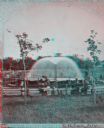
| Date: | 1880 |
|---|---|
| Description: | Stereograph of the Artesian Well near the intersection of Wisconsin and Minnesota (later renamed Wacouta) Streets. The following is printed on the backside... |
| Date: | 1875 |
|---|---|
| Description: | "Iron Bridge across Mississippi" photographed during "The Norwegian Lutheran Synod held at Minneapolis, Minn., 1875," as described in Dahl's 1877 "Catalogu... |

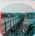
| Date: | 1870 |
|---|---|
| Description: | Stereograph of John Lawler's pile-pontoon railway bridge over the Mississippi River. |

| Date: | 1842 |
|---|---|
| Description: | A map of the Western rivers, a "travellers guide" exhibiting the Mississippi, Missouri, Ohio and Illinois Rivers with principal towns. |

| Date: | 1862 |
|---|---|
| Description: | This map lists and depicts the positions of "the batteries on Kentucky shore" and the "batteries on Island No. 10." The 8th Wisconsin Infantry and 15th Wis... |

| Date: | 1860 |
|---|---|
| Description: | This colored map shows railroad lines east of the Mississippi as well as in the states bordering the Mississippi River. The Great Lakes and Gulf of Mexico ... |

| Date: | 1844 |
|---|---|
| Description: | A hand-colored map and chart showing a geological cross-section from Rockingham, in present-day Scott County, Iowa, through Blue Mounds to the Wisconsin Ri... |

| Date: | 1835 |
|---|---|
| Description: | Ink on tracing paper map of Green Bay, Wisconsin and nearby areas, Lake Winnebago, Fox and Wolf Rivers, and the junctions of the Mississippi and Wisconsin ... |

| Date: | 1852 |
|---|---|
| Description: | Hand-colored maps and a series of geological cross sections of the Mississippi River between the Falls of St. Anthony and the mouth of the Wisconsin River ... |

| Date: | 1850 |
|---|---|
| Description: | A hand-colored map showing portions of present-day Iron and Vilas counties north of the Manitowish River as part of the Upper Peninsula of Michigan. The Wi... |
If you didn't find the material you searched for, our Library Reference Staff can help.
Call our reference desk at 608-264-6535 or email us at: