 Filter: Categories of Wisconsin Historical Images
Filter: Subject of Mississippi River
Filter: Year of 1800-1899
Filter: Categories of Wisconsin Historical Images
Filter: Subject of Mississippi River
Filter: Year of 1800-1899

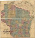
| Date: | 1871 |
|---|---|
| Description: | This map of Wisconsin and surrounding states depicts the township survey grid and identifies counties, named towns, cities and villages, rivers, lakes, rai... |

| Date: | 1871 |
|---|---|
| Description: | This map of Wisconsin and surrounding states depicts the township survey grid and identifies counties, named towns, cities and villages, rivers, lakes, rai... |
| Date: | 1872 |
|---|---|
| Description: | This map of Wisconsin depicts the township survey grid and identifies counties, named towns, cities and villages, rivers, lakes, railroads, and the Chippew... |

| Date: | 1872 |
|---|---|
| Description: | This map, which includes eastern Iowa, northern Illinois and a portion of Michigan's Upper peninsula, shows the township survey grid and identifies countie... |

| Date: | 1874 |
|---|---|
| Description: | This hand-colored map shows the railroads "completed" "in progress" and "contemplated" rivers, counties, cities and villages, and named towns in the state,... |

| Date: | 1873 |
|---|---|
| Description: | This hand-colored map of Wisconsin depicts the township survey grid and identifies counties, named towns, cities and villages, rivers, lakes, railroads, an... |

| Date: | 1874 |
|---|---|
| Description: | This hand-colored map of Wisconsin and the western portion of Michigan's Upper Peninsula, shows the township grid, railroads completed and in progress, cou... |

| Date: | 1875 |
|---|---|
| Description: | This hand-colored map of Wisconsin and the western portion of Michigan's Upper Peninsula depicts the township survey grid and identifies counties, named to... |

| Date: | 1835 |
|---|---|
| Description: | Plat for a proposed Sinsinawa City (never built), in Grant County, Wis. When it became clear in the mid-1830s that Wisconsin Territory would be established... |

| Date: | 02 1823 |
|---|---|
| Description: | A map featuring the North American expedition from Pittsburgh to the Rocky Mountains led by Edwin James. |

| Date: | 1878 |
|---|---|
| Description: | A hand-colored map of Wisconsin and the western portion of Michigan’s Upper Peninsula, showing the railroads that are completed and in progress, counties, ... |

| Date: | 1878 |
|---|---|
| Description: | A hand-colored, cloth mounted, sectional map of Wisconsin and the western portion of Michigan’s Upper Peninsula, showing the township grid, railroads, town... |

| Date: | 1880 |
|---|---|
| Description: | A hand-colored, sectional map of Wisconsin showing the township grid, railroads, counties, towns, cities, villages, and the Menomonee, Oneida, Flambeau, an... |

| Date: | 1881 |
|---|---|
| Description: | A hand-colored, cloth mounted, sectional map of Wisconsin showing the township grid, completed and proposed railroads, counties, towns, cities, villages. T... |

| Date: | 1882 |
|---|---|
| Description: | A hand-colored, sectional map of Wisconsin showing the township grid, completed and proposed railroads, counties, towns, cities, villages. The map also inc... |

| Date: | 1890 |
|---|---|
| Description: | View over water of a three-decked sternwheeler loaded with passengers and flying two large flags. The one at the back is a United States flag. There is a s... |
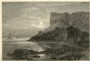
| Date: | 1874 |
|---|---|
| Description: | Engraved view of Maiden's Rock at Lake Pepin. A steamboat is on the Mississippi River. |

| Date: | 1873 |
|---|---|
| Description: | A map that covers parts of Winona and Houston Counties, Minnesota and La Crosse County, Wisconsin, showing the proposed railroad routes, constructed rail l... |

| Date: | 1875 |
|---|---|
| Description: | This map, from G.K. Warren's 1876 Report on the transportation route along the Wisconsin and Fox rivers in the State of Wisconsin between the Mississippi R... |
If you didn't find the material you searched for, our Library Reference Staff can help.
Call our reference desk at 608-264-6535 or email us at:
