 Filter: Categories of Wisconsin Historical Images
Filter: Subject of Mississippi River
Filter: Subject of technology
Filter: Categories of Wisconsin Historical Images
Filter: Subject of Mississippi River
Filter: Subject of technology

| Date: | 1900 |
|---|---|
| Description: | Elevated view of the brewery dwarfed by the overhead bluffs. The brewery was built by William Schmitz. George Scheibl ran the brewery from 1899 until his d... |

| Date: | 1895 |
|---|---|
| Description: | View down road with the Bay State House on the left. Three houses and a barbershop also line the street. A lamppost is in the left foreground. The Mississ... |

| Date: | 1998 |
|---|---|
| Description: | A couple walking along the riverfront in winter, with a bridge across the Mississippi in the background. |
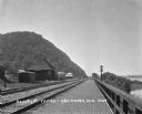
| Date: | 1909 |
|---|---|
| Description: | View along a brick platform towards the Glen Haven depot, where two men stand against the building. Behind the depot is a building with a sign for the "Me... |

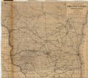
| Date: | 1877 |
|---|---|
| Description: | A map of the triangulation and reconnaissance along the southwest corner of Wisconsin. The map shows the river systems, railroads, cities, and villages tha... |

| Date: | 1855 |
|---|---|
| Description: | This map shows the entire state and part of the Upper Peninsula of Michigan. It depicts creeks, rivers, lakes, railroads completed, railroads in progress, ... |

| Date: | 1855 |
|---|---|
| Description: | This map shows the township survey grid and identifies counties, named towns, rivers, lakes, railroads, plank roads, mines, and the Menomonee Reservation. ... |

| Date: | 1857 |
|---|---|
| Description: | This map depicts the township survey grid in Wisconsin, Michigan, northern Illinois, eastern Iowa, and southeastern Minnesota. Counties, named towns, citie... |

| Date: | 1857 |
|---|---|
| Description: | This map shows the township survey grid and identifies counties, named towns, cities and villages, rivers, lakes, and railroads. Boundaries are shown in bl... |

| Date: | 1864 |
|---|---|
| Description: | This map of the entire state of Wisconsin depicts the township survey grid and identifies counties, named towns, cities and villages, rivers, lakes, railro... |

| Date: | 1875 |
|---|---|
| Description: | These maps, from G.K. Warren's 1876 Report on the transportation route along the Wisconsin and Fox rivers in the State of Wisconsin between the Mississippi... |

| Date: | 04 10 2014 |
|---|---|
| Description: | The owner of La Crosse Radio Group, Jacklyn Daniels, gazes out of the window at the riverside. The event was the DMI Trend Showcase in the Cargill Room. S... |

| Date: | 1975 |
|---|---|
| Description: | This map provides an index of quadrangle maps for the state. The lower left corner contains explanation land surveying completeness. Communities, counties,... |

| Date: | 1975 |
|---|---|
| Description: | This map provides an index of outdated quadrangle maps for the state. Communities, counties, rivers, and lakes are labeled including Lake Michigan and Lake... |
| Date: | 1879 |
|---|---|
| Description: | This map shows names of triangulation stations, railroads, counties, rivers, and lakes. The Mississippi River, Lake Winnebago, and Lake Michigan are labele... |

| Date: | 12 21 2014 |
|---|---|
| Description: | View of a child walking on a walkway with metal railings. There is a light shining down on her from a wall on the left. In the background is a slope going ... |
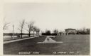
| Date: | |
|---|---|
| Description: | View of the cannon at Riverside Park. Automobiles are parked by the river on the left. Caption reads: "Riverside Park, La Crosse, Wis." |

| Date: | 05 08 1927 |
|---|---|
| Description: | Six actors are standing outdoors. One of them men is holding a flag a fleur-de-lis design in a reenactment of a ceremony in which Nicolas Perrot claimed th... |

| Date: | 08 12 2020 |
|---|---|
| Description: | Man viewing fog on the Mississippi River from a bench in Riverside Park. |
If you didn't find the material you searched for, our Library Reference Staff can help.
Call our reference desk at 608-264-6535 or email us at: