 Filter: Categories of Wisconsin Historical Images
Filter: Subject of Mississippi River
Filter: Subject of landforms
Filter: Categories of Wisconsin Historical Images
Filter: Subject of Mississippi River
Filter: Subject of landforms
| Date: | 1858 |
|---|---|
| Description: | In August 1858, Hölzlhuber traveled up the St. Croix River to Stillwater, Minnesota, on the steamship Winona. He noted the upper Mississippi's tribu... |

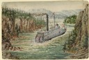
| Date: | 1872 |
|---|---|
| Description: | The sidewheel packet, Red Wing, in the Mississippi River near Queen's Bluff below Trempealeau, Wisconsin. |
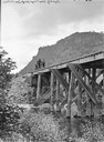
| Date: | |
|---|---|
| Description: | Upper Mississippi, view at Riley's Coolie. Four men are on a railroad handcar that is crossing a railroad bridge over the river. |

| Date: | 1880 |
|---|---|
| Description: | Bird's-eye map over the Mississippi River of Fountain City. Paddle steamers and steamboats are on the river, and bluffs are in the background. |

| Date: | |
|---|---|
| Description: | Two men posing on bluffs overlooking the Mississippi River at Fountain City. Fountain Brewery is visible at bottom right. |

| Date: | 1829 |
|---|---|
| Description: | Drawing of Cassville depicting a horse cart on the river's edge, with men and boats. |

| Date: | 1875 |
|---|---|
| Description: | Aerial view of Alma along Mississippi River, with bluffs along the horizon. |
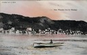
| Date: | 1905 |
|---|---|
| Description: | View of Alma across the Mississippi River, with a man in a rowboat in the foreground. Caption reads: "Alma, Wisconsin, from the Mississippi." |

| Date: | 1900 |
|---|---|
| Description: | Elevated view of the brewery dwarfed by the overhead bluffs. The brewery was built by William Schmitz. George Scheibl ran the brewery from 1899 until his d... |
| Date: | |
|---|---|
| Description: | Cassville from the bluffs. Bluffs are in the right side of the image, and the view overlooks the town. The church is the dominant structure, and the river ... |

| Date: | |
|---|---|
| Description: | Elevated view from bluff of a house in Cassville surrounded by bluffs, trees and farmland. Railroad tracks run between the crops and the trees, and the Mis... |
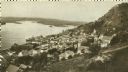
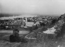
| Date: | 1920 |
|---|---|
| Description: | Elevated view of Fountain City with the Mississippi River in the background. |

| Date: | 1900 |
|---|---|
| Description: | Elevated view of La Crosse. Caption reads: "Panorama of La Crosse, Wis. from Grand Dad's Bluff." |

| Date: | 1804 |
|---|---|
| Description: | A map of Lewis and Clark's Track across the western portion of North America from the Mississippi River to the Pacific Ocean by order of the Executive of t... |

| Date: | 1910 |
|---|---|
| Description: | Colorized view of the Maiden's Rock, as viewed from Lake City, Minnesota. This was the legendary lover's leap of Wenonah, the first-born daughter of Dakota... |

| Date: | 1905 |
|---|---|
| Description: | The view of the Lake Front from across the Mississippi River. Caption reads: "Lake Front at Maiden Rock, Wis." |

| Date: | 1829 |
|---|---|
| Description: | Cincinnati, Ohio, Ebr. Martin, engraver. |

| Date: | 1882 |
|---|---|
| Description: | This basic reference map of the state shows natural features, railroads, county seats, and political boundaries against the G.L.O. township and range grid.... |

| Date: | 1910 |
|---|---|
| Description: | Wisconsin Geological and Natural History Survey, by Lawrence Martin reproduced from a model of the state prepared by W.O. Hotchkiss and F.T. Thwaites and m... |

| Date: | 1868 |
|---|---|
| Description: | Showing the counties, towns and railroads. Partly colored. Scale: 1 inch = 20 miles. |
If you didn't find the material you searched for, our Library Reference Staff can help.
Call our reference desk at 608-264-6535 or email us at: