Filter: Categories of Wisconsin Historical Images
Filter: Subject of Mississippi River
Filter: Subject of land use, rural
Filter: Categories of Wisconsin Historical Images
Filter: Subject of Mississippi River
Filter: Subject of land use, rural

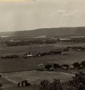
| Date: | 1875 |
|---|---|
| Description: | Aerial view of Alma along Mississippi River, with bluffs along the horizon. |

| Date: | 1829 |
|---|---|
| Description: | Hand-colored lithograph of Fort Armstrong on Rock Island, based on a drawing by Henry Lewis. Foreground shows a tree floating in the water. |

| Date: | 1829 |
|---|---|
| Description: | Hand-colored lithograph of Fort Armstrong, based on a drawing by Henry Lewis. Includes boats on the Mississippi River. |

| Date: | |
|---|---|
| Description: | View from below of wood burning locomotive and single car on elevated railroad bridge and approach trestle, somewhere along the upper Mississippi River. La... |

| Date: | 1910 |
|---|---|
| Description: | A small cottage in a wooded setting. There is a small boat with a man on the shoreline. There is a steep bluff on the far shoreline. A Frank Feiker 'Souven... |
| Date: | 1905 |
|---|---|
| Description: | Large rock formation with farm outbuildings, and what appears to be railroad tracks at the base. The Mississippi River is in the foreground. Crop on image ... |

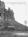
| Date: | 1904 |
|---|---|
| Description: | Panoramic view of Governor Nelson Dewey's estate. The left image is of an old stone barn with a shed in the rear. The center image is another barn. The rig... |

| Date: | 1910 |
|---|---|
| Description: | This map shows the Soo Line railroad and Arpin Hardwood Lumber Company lands in red. The top margin of the map reads: "Wisconsin, the safest state in the U... |

| Date: | 1758 |
|---|---|
| Description: | This detailed map of north eastern America shows the boundaries, cities, mountains, rivers, lakes, Native American land and towns, and roads from east of t... |
If you didn't find the material you searched for, our Library Reference Staff can help.
Call our reference desk at 608-264-6535 or email us at: