 Filter: Categories of Wisconsin Historical Images
Filter: Subject of Mississippi River
Filter: Subject of land
Filter: Categories of Wisconsin Historical Images
Filter: Subject of Mississippi River
Filter: Subject of land

| Date: | 1895 |
|---|---|
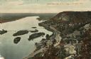
| Description: | Elevated view from bluffs, looking north-east toward Lake City, Minnesota and Lake Pepin of the Mississippi River. |

| Date: | 04 09 1936 |
|---|---|
| Description: | The Buffalo Head, a 'native' stone sculpture by the Mississippi River at the junction of Flint Ledge and Indian trails in Wyalusing State Park. The verso... |

| Date: | 1936 |
|---|---|
| Description: | Four men are building the wall at Signal Point Lookout in Wyalusing State Park. They are part of Works Progress Administration (WPA) Project #8656-8. Th... |

| Date: | 1899 |
|---|---|
| Description: | This map is a folded insert from the pamphlet "Yesterday and Today : A History." The map features the North-Western Line with labeled railway tracks and st... |

| Date: | 1890 |
|---|---|
| Description: | This map features township outlines, railroads, roads, post offices, and landownership for La Crosse County. Various communities appear in yellow, green, a... |

| Date: | 1882 |
|---|---|
| Description: | This map is ink on cardboard and shows the location of military forts over the course of years. Also shown are points of interest, streets, the Mississippi... |

| Date: | 1950 |
|---|---|
| Description: | Intended for tourists, this brochure features two maps with tourists sites along the Mississippi River. One map shows roads and populated places along the ... |

| Date: | 1976 |
|---|---|
| Description: | This map includes an index of streets, government and historic buildings, hospitals, schools, places of recreation, churches, cemeteries, and other miscell... |

| Date: | 1800 |
|---|---|
| Description: | This map is ink and watercolor on paper and shows the main channel and sand bars in the Mississippi River between villages. |

| Date: | 1916 |
|---|---|
| Description: | This map is mounted on cloth and shows lots and roads. An inset map is included that shows towns, lakes, rivers, and railroads within portions of the Dakot... |
| Date: | 1910 |
|---|---|
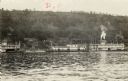
| Description: | Black and white photographic postcard view across water towards three steamboats on the shoreline of the Mississippi River. |
| Date: | 1910 |
|---|---|
| Description: | Color enhanced aerial view of the village of DeSoto, looking north along the Mississippi River. Caption reads: "Bird's Eye View of the Village of De Soto, ... |
| Date: | 1920 |
|---|---|
| Description: | Black and white photographic postcard view of De Soto, taken from the cliff south of town, looking north along the Mississippi River. Caption reads: "A Vie... |

| Date: | 1838 |
|---|---|
| Description: | This map is a development plat that shows street names, numbered blocks and lots, and small farm lot owners. Included on the right of the map is a large am... |

| Date: | 06 1853 |
|---|---|
| Description: | This map is ink, pencil, and color on paper and shows lot and block numbers and dimensions, sold lots, streets, and the Mississippi River. Some lots are co... |

| Date: | 1856 |
|---|---|
| Description: | This map shows lot and block numbers, streets, the Mississippi River, Fort Crawford, depot ground, and a graveyard. An old fort location is outlined in red... |

| Date: | 12 05 1854 |
|---|---|
| Description: | This plat map shows landowners, the Mississippi River, the Marais de St. Friole, and an old fort. The left margin reads: "Part of the Main Village of Prair... |

| Date: | 1828 |
|---|---|
| Description: | This plat map is pen-and-ink and shows landowners, the Mississippi River, the Marais de St. Friole, Fort Crawford, the town commons, and the Village of St.... |

| Date: | 1828 |
|---|---|
| Description: | This map is pen-and-ink and served as the model for the lithograph produced in 1828 by C.B. Graham. Landowners are labeled as is the Mississippi River. |
| Date: | 1905 |
|---|---|
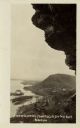
| Description: | View across top of platform mound on the crest of a high hill. Trees are on the left and right. In the background below is the Mississippi River. |
If you didn't find the material you searched for, our Library Reference Staff can help.
Call our reference desk at 608-264-6535 or email us at: