 Filter: Categories of Wisconsin Historical Images
Filter: Subject of Mississippi River
Filter: Subject of land
Filter: Categories of Wisconsin Historical Images
Filter: Subject of Mississippi River
Filter: Subject of land

| Date: | 12 1914 |
|---|---|
| Description: | Photographic postcard view of southern Alma with buildings and bluffs. The Mississippi River and the shoreline are in the foreground. Caption reads: "Alma,... |
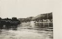
| Date: | 1908 |
|---|---|
| Description: | Scene of the town of Alma from the Mississippi River. Alma and the bluffs along the Mississippi are in the far background. A paddle steamer can be seen flo... |

| Date: | 1923 |
|---|---|
| Description: | Photographic postcard of scenes from Alma. Three scenes from areas around Alma show the town along the Mississippi River, an elevated view of the river bet... |

| Date: | 08 03 1913 |
|---|---|
| Description: | Colorized postcard of the Mississippi River and bluffs near Alma. A docked paddle boat is near the shoreline. Caption reads: "A Scene from the River, Alma,... |

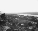
| Date: | 04 12 1907 |
|---|---|
| Description: | Photographic postcard of an aerial view of town looking North. The Mississippi River is on the left. |
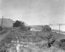
| Date: | 1921 |
|---|---|
| Description: | View from bluff of Cassville with the Mississippi River in the background. |
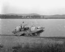
| Date: | 1921 |
|---|---|
| Description: | View from shoreline looking down at three men posing on a paddle steamer ferry boat carrying an automobile. The boat has the words "Cassville" and "Dewey" ... |

| Date: | 1928 |
|---|---|
| Description: | This map shows geological formations throughout Wisconsin. Lakes and rivers are labeled, including The Mississippi River, Lake Superior, and Lake Michigan.... |
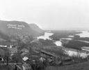
| Date: | 1914 |
|---|---|
| Description: | View down path along rough road towards a building labeled "No. 4". The De Soto Depot, railroad tracks, a boxcar, and the Mississippi River are below on th... |
| Date: | |
|---|---|
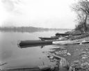
| Description: | View of shoreline of boats tied along the banks the Mississippi River. A fish net drying reel is near the boats and a wooden walkway. The far shoreline is ... |
| Date: | |
|---|---|
| Description: | A blurred image of a man as he is walking across the unpaved street which goes down to the Mississippi River. The Bay State House and more storefronts are ... |
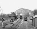
| Date: | 1912 |
|---|---|
| Description: | Elevated view of the De Soto depot. A locomotive, blowing steam, is approaching the platform, where a small group of people waits to board. A boxcar on the... |
| Date: | |
|---|---|
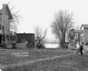
| Description: | View looking down bluff of a residential neighborhood. On the right is the Mississippi River. Railroad tracks run along the shoreline towards more bluffs. |
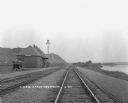
| Date: | 1925 |
|---|---|
| Description: | View down double set of railroad tracks with the De Soto depot on the left and the Mississippi River on the right. A car is parked at the depot, and bluffs... |

| Date: | 1862 |
|---|---|
| Description: | This map lists and depicts the positions of "the batteries on Kentucky shore" and the "batteries on Island No. 10." The 8th Wisconsin Infantry and 15th Wis... |

| Date: | 1930 |
|---|---|
| Description: | Pen and ink map on paper of Wisconsin and northern Illinois showing stagecoach routes (marked in red) that traveled between Lake Michigan and the Mississip... |

| Date: | 1919 |
|---|---|
| Description: | This map depicts the route of the 1842 overland trip by wagon made by the Reverend Alfred Brunson and some copper miners from Prairie du Chien to the mouth... |

| Date: | 1935 |
|---|---|
| Description: | This map shows Wisconsin’s pinery region. Lake Superior, Lake Michigan, Lake Winnebago, Green Bay, the Wisconsin River, and the Mississippi River are label... |

| Date: | 1920 |
|---|---|
| Description: | Shows 10 land and water trails along rivers and other bodies of water in northern Wisconsin and the Upper Peninsula of Michigan; each trail numbered and de... |

| Date: | 1942 |
|---|---|
| Description: | This map shows the Wisconsin and Fox River routes in green, and the Milwaukee and Rock River Canal routes in red. Prairie du Chien, Fort Winnebago, Grand C... |
If you didn't find the material you searched for, our Library Reference Staff can help.
Call our reference desk at 608-264-6535 or email us at: