 Filter: Categories of Wisconsin Historical Images
Filter: Subject of Mississippi River
Filter: Subject of land
Filter: Creator Name of Unknown
Filter: Categories of Wisconsin Historical Images
Filter: Subject of Mississippi River
Filter: Subject of land
Filter: Creator Name of Unknown

| Date: | 1776 |
|---|---|
| Description: | Map of the American colonies and land east of the Mississippi River. Prominent cities, forts, Native American land, mountains, rivers and lakes are all sho... |

| Date: | 1782 |
|---|---|
| Description: | Map of America east of the Mississippi River. It shows regions, state boundaries extending to the Mississippi River, cities, forts, Native American lands, ... |

| Date: | 1720 |
|---|---|
| Description: | Map showing the course of the Mississippi River from the Gulf of Mexico up past Lake Superior into Canada. It shows the towns, Native American tribes and l... |

| Date: | 1761 |
|---|---|
| Description: | Map covering southern Louisiana from Lake Ponchetrain to the Golf of Mexico and from Woods Bay in the west to the islands just east of Bay St. Louis. It sh... |

| Date: | 1755 |
|---|---|
| Description: | Map of the Great Lakes region during the French and Indian War. It shows in great detail the territories, borders and boundary lines, Native American tribe... |

| Date: | 1905 |
|---|---|
| Description: | Aerial view of Fountain City and the Mississippi River. Caption reads: "Fountain City, Wis." |

| Date: | 1905 |
|---|---|
| Description: | View of Fountain City from the Mississippi River. There is a steamer at the dock on the far shoreline. Hills in the background are reflected in the water. |

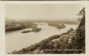
| Date: | 1910 |
|---|---|
| Description: | Elevated view of Fountain City, with the Mississippi River on the right, and hills in the background on the left. Caption reads: "Fountain City, Wis." |

| Date: | |
|---|---|
| Description: | A bathing beach on an island near a bridge, with people in the water and on the beach within an enclosed area. A canoe and rowboat are pulled up on the sho... |
| Date: | |
|---|---|
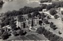
| Description: | Aerial view of an orphanage and grounds near the Mississippi River. Caption reads: "St. Michael's Orphanage — La Crosse, Wis." |

| Date: | |
|---|---|
| Description: | View from shoreline towards the paddle steamer "G.W. Hill" on the Mississippi River. Caption reads: "Steamer G.W. Hill taking excursion out of La Crosse, W... |

| Date: | |
|---|---|
| Description: | View from shoreline towards the Mississippi River, with the sun shining through the clouds and sparkling on the water. Hills are in the distance. Caption r... |
| Date: | 1902 |
|---|---|
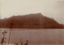
| Description: | View of a tree-lined mountain across a body of water. Caption reads: "Trempealeau Mountain from across the bay." |
| Date: | 02 02 1927 |
|---|---|
| Description: | Elevated view of a cliff side overlooking a river. Caption reads: "Eagle Cliff, or Second Peak, in Perrot State Park. Donor Dr. Eben Pierce. Near Trempeale... |
| Date: | |
|---|---|
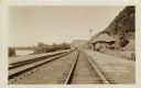
| Description: | View down railroad tracks running along the Mississippi River past a depot. Men are walking near the depot. Caption reads: "C.B.&O. Yards, Lynxville, Wis." |
| Date: | |
|---|---|
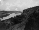
| Description: | Elevated view of the Mississippi River at Lynxville. Railroad tracks are running alongside the shoreline. Caption reads: "Looking N.W. from Lynxville, Wis.... |

| Date: | |
|---|---|
| Description: | Aerial view of the Holiday Inn, between La Crosse on Barron Island in the beautiful Mississippi. A curved road is leading to a bridge across the Mississipp... |

| Date: | |
|---|---|
| Description: | View down railroad tracks along shoreline. Printed sign at right reads: "Burlington Route." Text at bottom reads: "Maiden Rock, Wisconsin — of romantic int... |
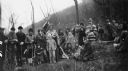
| Date: | 05 08 1927 |
|---|---|
| Description: | A large group of actors posing together outdoors while in costume. They are participants in a reenactment of a ceremony in which Nicolas Perrot claimed the... |

| Date: | 05 08 1927 |
|---|---|
| Description: | Two men are standing by a sign, near a fence, marking the former location of Fort Antoine. |
If you didn't find the material you searched for, our Library Reference Staff can help.
Call our reference desk at 608-264-6535 or email us at: