 Filter: Categories of Wisconsin Historical Images
Filter: Subject of Mississippi River
Filter: Subject of ferries
Filter: Categories of Wisconsin Historical Images
Filter: Subject of Mississippi River
Filter: Subject of ferries
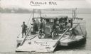
| Date: | 1920 |
|---|---|
| Description: | The Cassville Ferry with three cars and passengers, crossing the Mississippi River from Cassville to Turkey River, Iowa. |
| Date: | |
|---|---|
| Description: | View across water toward a railroad train and locomotive on a ferry going across the Mississippi River near New Orleans. |
| Date: | 1938 |
|---|---|
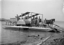
| Description: | View from road leading down to shoreline of a Mississippi River ferry bringing several cars across the river. |
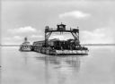
| Date: | 1921 |
|---|---|
| Description: | View from shoreline looking down at three men posing on a paddle steamer ferry boat carrying an automobile. The boat has the words "Cassville" and "Dewey" ... |
| Date: | 1907 |
|---|---|
| Description: | Horse-powered Mississippi River Ferry. This ferry was operated between Turkey river, Iowa and Cassville, Wisconsin by Alfred Dietrich. |
| Date: | 1910 |
|---|---|
| Description: | View along shoreline of man examining a rowboat while crouching in the water wearing boots. Behind him is a ferry. There are several men on the shore watch... |

| Date: | 1939 |
|---|---|
| Description: | This nine-part map from the U.S. Bureau of Public Roads identifies federal and state highways in Wisconsin by pavement type. County, forest, park, and publ... |

| Date: | 1944 |
|---|---|
| Description: | This nine-part map from the U.S. Bureau of Public Roads identifies federal and state highways in Wisconsin by pavement type. County, forest, park, and publ... |

| Date: | 1950 |
|---|---|
| Description: | This road map shows federal, state and county roads in Wisconsin, northern Illinois, northeastern Iowa, eastern Minnesota, and the western portion of Michi... |

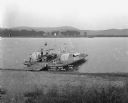
| Date: | 1915 |
|---|---|
| Description: | View from shoreline of ferry carrying three automobiles on the Mississippi River. An excursion boat is in the water nearby, and buildings are on the far sh... |

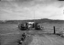
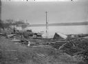
| Date: | 1915 |
|---|---|
| Description: | Ferry tied up at the Cassville dock. A number of men are standing along the shoreline. |

| Date: | 1900 |
|---|---|
| Description: | This map shows the boundary lines between ceded and unceded land in compliance with the Treaty of Prairie du Chen of 1829. It also shows roads, rivers, por... |

| Date: | 1928 |
|---|---|
| Description: | This map shows the entire state of Wisconsin as well as portions of Michigan, Minnesota, Iowa and Illinois. Lake Michigan, Lake Superior, Lake Winnebago a... |

| Date: | 1934 |
|---|---|
| Description: | This road map contains automobile routes for the state of Wisconsin as well as portions of Minnesota, Illinois, Iowa and Michigan. Lake Michigan, Lake Sup... |
If you didn't find the material you searched for, our Library Reference Staff can help.
Call our reference desk at 608-264-6535 or email us at: