Filter: Categories of Wisconsin Historical Images
Filter: Subject of Mississippi River
Filter: Subject of canoes and canoeing
Filter: Categories of Wisconsin Historical Images
Filter: Subject of Mississippi River
Filter: Subject of canoes and canoeing

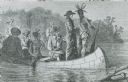
| Date: | 1921 |
|---|---|
| Description: | Painted scene of an Indian guide paddling, Jacques Marquette, a Jesuit missionary standing, and Louis Joliet, a fur trader paddling in a canoe exploring th... |

| Date: | 10 1829 |
|---|---|
| Description: | Fort Crawford as drawn by Seth Eastman. People are in a canoe in the river in the foreground. Across the river is the fort, other buildings around the fort... |

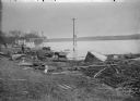
| Date: | 1873 |
|---|---|
| Description: | The harbor, showing the sidewheel packet, "Belle of La Crosse," and the sidewheel ferry "Alex McGregor." Other boats are also seen including two barges loa... |

| Date: | 1873 |
|---|---|
| Description: | Bird's-eye map of La Crosse from the Mississippi River. |

| Date: | |
|---|---|
| Description: | A painting depicting Marquette and Joliet in a birch bark canoe with two other men during their excursion on the Mississippi River, which they discovered o... |

| Date: | 1890 |
|---|---|
| Description: | Collage of scenes on the upper Mississippi River, including people canoeing and sailing on the river. |

| Date: | 1908 |
|---|---|
| Description: | Photographic postcard view over the Mississippi River showing of the town of Alma. Bluffs are behind the town. In the foreground, two men wearing hats are ... |
| Date: | 1910 |
|---|---|
| Description: | View along shoreline of man examining a rowboat while crouching in the water wearing boots. Behind him is a ferry. There are several men on the shore watch... |

| Date: | 1910 |
|---|---|
| Description: | View from shoreline of small launch with two canoes and a rowboat on the shoreline of the Mississippi River. There is a child in the canoe in the foregroun... |

| Date: | 1783 |
|---|---|
| Description: | This map is hand-colored and shows the boundaries of British, Spanish, and the newly recognized American claims, as well as the fishing rights granted to F... |

| Date: | 1718 |
|---|---|
| Description: | Map of the Southern portion of North America from New Mexico to Florida and south from Lake Erie. It shows borders, cities, settlements, Native American la... |

| Date: | |
|---|---|
| Description: | A bathing beach on an island near a bridge, with people in the water and on the beach within an enclosed area. A canoe and rowboat are pulled up on the sho... |
If you didn't find the material you searched for, our Library Reference Staff can help.
Call our reference desk at 608-264-6535 or email us at: