Filter: Categories of Wisconsin Historical Images
Filter: Subject of Mississippi River
Filter: Reproduction Rights of For Sale
Filter: Community of Prairie du Chien
Filter: Categories of Wisconsin Historical Images
Filter: Subject of Mississippi River
Filter: Reproduction Rights of For Sale
Filter: Community of Prairie du Chien

| Date: | 10 1829 |
|---|---|
| Description: | Fort Crawford as drawn by Seth Eastman. People are in a canoe in the river in the foreground. Across the river is the fort, other buildings around the fort... |

| Date: | 1870 |
|---|---|
| Description: | During the War of 1812, the only battle fought in Wisconsin was in Prairie du Chien, in 1814. Made fifty-six years later, this birds eye drawing depicts th... |
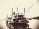
| Date: | |
|---|---|
| Description: | A bow view of the Sidney. Later named the Washington. |
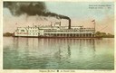
| Date: | |
|---|---|
| Description: | The sidewheel excursion, "Saint Paul" of the Jo Packet Line, near the Dousman House, the "Senator". Caption reads: "Steamer near Dousman House, Prairie du ... |
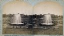
| Date: | 1880 |
|---|---|
| Description: | Stereograph of the Artesian Well near the intersection of Wisconsin and Minnesota (later renamed Wacouta) Streets. The following is printed on the back of ... |

| Date: | 1848 |
|---|---|
| Description: | The first Fort Crawford at Prairie du Chien, with the Mississippi River in the foreground. Although dated 1830, this scene was actually painted by Henry Le... |

| Date: | 1884 |
|---|---|
| Description: | Bird's-eye view drawing of the grounds of Villa Louis, the estate of the fur trading Dousman family. After the death of H. Louis Dousman's mother in 1882, ... |
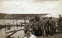
| Date: | 10 19 1911 |
|---|---|
| Description: | Aviator Hugh Robinson and his Curtiss flying boat on the Mississippi River. |
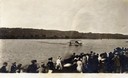
| Date: | 10 19 1911 |
|---|---|
| Description: | A crowd gathered on the Mississippi River shoreline near Prairie du Chien. They are watching pioneer aviator Hugh Robinson taxi his Curtiss flying boat. |
| Date: | 1880 |
|---|---|
| Description: | Stereograph of the Artesian Well near the intersection of Wisconsin and Minnesota (later renamed Wacouta) Streets. The following is printed on the backside... |
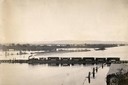
| Date: | |
|---|---|
| Description: | Elevated view of the pile-pontoon railroad bridge across the Mississippi River at Prairie du Chien. The bridge was built and patented by John Lawler in 187... |

| Date: | 1820 |
|---|---|
| Description: | A manuscript map of Prairie du Chien. |
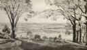
| Date: | 1954 |
|---|---|
| Description: | View from Brisbois Point. Prairie du Chien lies below, and beyond the Mississippi River rise Iowa's hills. |

| Date: | 1836 |
|---|---|
| Description: | Woodcut of Prairie du Chien in 1836. Text at bottom reads: "Prairie du Chien in 1836. From an old cut." |
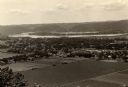
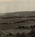
| Date: | 1910 |
|---|---|
| Description: | Elevated view from Brisbois Bluff of town, Mississippi River, and hills beyond. |
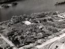
| Date: | 1960 |
|---|---|
| Description: | Aerial view of Villa Louis on the Mississippi River, and adjacent buildings. |
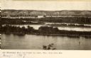
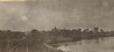
| Date: | 1905 |
|---|---|
| Description: | View looking toward old Diamond Jo Warehouse, before the bridge was built. Caption reads: "Mississippi River and Prairie du Chien, Wis., from Iowa Side". |
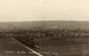
| Date: | 1930 |
|---|---|
| Description: | Elevated view of the north side of town, from high on the bluff. Caption reads: "'Birdseye' No. End Prairie Du Chien, Wis." |
| Date: | 1905 |
|---|---|
| Description: | View along curving railroad tracks towards town, with the river along the right. St. Mary's Academy is among trees in the center. |
If you didn't find the material you searched for, our Library Reference Staff can help.
Call our reference desk at 608-264-6535 or email us at: