 Filter: Categories of Wisconsin Historical Images
Filter: Subject of Mississippi River
Filter: County of La Crosse
Filter: Categories of Wisconsin Historical Images
Filter: Subject of Mississippi River
Filter: County of La Crosse

| Date: | 1970 |
|---|---|
| Description: | This map is intended for tourists of La Crosse. The cover features images of farms and natural land and reads: "friends are but strangers... we have yet to... |

| Date: | 1972 |
|---|---|
| Description: | This map of La Crosse is a plan for the city parks and recreation areas. The cover features an explanation of the Park and Recreation plan, objectives of t... |

| Date: | 1995 |
|---|---|
| Description: | This map of La Crosse is a bird’s-eye-view map with relief shown pictorially. The cover lists many points of interests and activities in La Crosse. The cov... |

| Date: | 1900 |
|---|---|
| Description: | This map of La Crosse shows twenty wards, some rural lots with acreages, streets, railroads, depots, bridges, cemeteries, parks, schools, islands, and the ... |

| Date: | 1857 |
|---|---|
| Description: | This map show city plats including the name and number of the plats as well as some land ownership. Some of the plats have manuscript annotations outlined ... |

| Date: | 1859 |
|---|---|
| Description: | This map show plats including plat names, plat numbers, and some lot owner's names. Relief is shown by hachures. The map includes line drawings of Juneau B... |

| Date: | 1872 |
|---|---|
| Description: | This map is pencil, ink, and watercolor on paper. Shown on the map is the elevation and profile of La Crescent Bottoms, Mt. Vernon Street line, 13th Street... |

| Date: | 1874 |
|---|---|
| Description: | This map has relief shown by hachures and includes 7 inset maps of additions and subdivisions with varying scales. Also includes index of additions and loc... |

| Date: | 1886 |
|---|---|
| Description: | This map has relief shown by hachures and includes a list of plats in order of date of record, laws which vacate plats, plats not shown as upon the county ... |

| Date: | 1888 |
|---|---|
| Description: | This map has relief shown by hachures and features inset maps of a plat of E.D. Clinton and Blackwell’s add’n to the City of La Crosse. Wards (1-10) shaded... |

| Date: | 1900 |
|---|---|
| Description: | The map is watercolor, pencil, and ink on tracing cloth and shows plats of both cities, local streets, railroads, mills, township divisions, bridges, and p... |

| Date: | 1857 |
|---|---|
| Description: | This map shows section corners, quarter section corners, foundry, steam saw mill, steam grist mill, planning mill, court house, baptist church, congregatio... |

| Date: | 1927 |
|---|---|
| Description: | This map includes an index and highways marked in red. Attractions on the map include: Four Mile House, Cold Springs, Grand Crossing Station, Coleman Sloug... |

| Date: | 04 09 1936 |
|---|---|
| Description: | The Buffalo Head, a 'native' stone sculpture by the Mississippi River at the junction of Flint Ledge and Indian trails in Wyalusing State Park. The verso... |
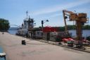
| Date: | 2012 |
|---|---|
| Description: | United States Coast Guard boat and a dredging barge at the Riverside Park, Levee Dock, a United States port facility on the Mississippi River. A brick walk... |

| Date: | 04 10 2014 |
|---|---|
| Description: | The owner of La Crosse Radio Group, Jacklyn Daniels, gazes out of the window at the riverside. The event was the DMI Trend Showcase in the Cargill Room. S... |

| Date: | 1890 |
|---|---|
| Description: | This map features township outlines, railroads, roads, post offices, and landownership for La Crosse County. Various communities appear in yellow, green, a... |

| Date: | 1883 |
|---|---|
| Description: | This map shows ward boundaries, names of additions, streets, bridges, mills, schools, religious buildings, businesses, hotels, railroads, factories, brewer... |

| Date: | 1891 |
|---|---|
| Description: | This hand-colored map shows platted additions and subdivisions, ward boundaries, schools, churches, railroads, cemeteries, parks, businesses, factories, an... |

| Date: | 1900 |
|---|---|
| Description: | This set of photocopy bird's-eye-view maps include one view looking west from the top of Wisconsin River bluffs; and a second view looking east towards La ... |
If you didn't find the material you searched for, our Library Reference Staff can help.
Call our reference desk at 608-264-6535 or email us at: