 Filter: Categories of Wisconsin Historical Images
Filter: Subject of Mississippi River
Filter: County of Crawford
Filter: Categories of Wisconsin Historical Images
Filter: Subject of Mississippi River
Filter: County of Crawford

| Date: | 1950 |
|---|---|
| Description: | Intended for tourists, this brochure features two maps with tourists sites along the Mississippi River. One map shows roads and populated places along the ... |

| Date: | 1976 |
|---|---|
| Description: | This map includes an index of streets, government and historic buildings, hospitals, schools, places of recreation, churches, cemeteries, and other miscell... |

| Date: | 1800 |
|---|---|
| Description: | This map is ink and watercolor on paper and shows the main channel and sand bars in the Mississippi River between villages. |
| Date: | 1910 |
|---|---|
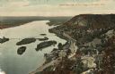
| Description: | Color enhanced aerial view of the village of DeSoto, looking north along the Mississippi River. Caption reads: "Bird's Eye View of the Village of De Soto, ... |
| Date: | 1920 |
|---|---|
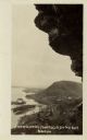
| Description: | Black and white photographic postcard view of De Soto, taken from the cliff south of town, looking north along the Mississippi River. Caption reads: "A Vie... |

| Date: | 1838 |
|---|---|
| Description: | This map is a development plat that shows street names, numbered blocks and lots, and small farm lot owners. Included on the right of the map is a large am... |

| Date: | 06 1853 |
|---|---|
| Description: | This map is ink, pencil, and color on paper and shows lot and block numbers and dimensions, sold lots, streets, and the Mississippi River. Some lots are co... |

| Date: | 1856 |
|---|---|
| Description: | This map shows lot and block numbers, streets, the Mississippi River, Fort Crawford, depot ground, and a graveyard. An old fort location is outlined in red... |

| Date: | 12 05 1854 |
|---|---|
| Description: | This plat map shows landowners, the Mississippi River, the Marais de St. Friole, and an old fort. The left margin reads: "Part of the Main Village of Prair... |

| Date: | 1828 |
|---|---|
| Description: | This plat map is pen-and-ink and shows landowners, the Mississippi River, the Marais de St. Friole, Fort Crawford, the town commons, and the Village of St.... |

| Date: | 1828 |
|---|---|
| Description: | This map is pen-and-ink and served as the model for the lithograph produced in 1828 by C.B. Graham. Landowners are labeled as is the Mississippi River. |

| Date: | 1900 |
|---|---|
| Description: | This map shows a line, marked with latitude and longitude coordinates that runs through Prairie du Chien. Only a few features beyond this line are displaye... |

| Date: | 1942 |
|---|---|
| Description: | This photocopy plat map represents the relative position and size of the sloughs and islands in the Mississippi River, opposite Prairie du Chien. |

| Date: | 1900 |
|---|---|
| Description: | This photocopy map shows blocks, lots, subdivisions, city wards, buildings, some landownership, and the Mississippi River. The map margins include business... |

| Date: | 1839 |
|---|---|
| Description: | This map shows the geological makeup of the valley in red, yellow, and green, the Mississippi River, and the location of Fort Crawford. The geology on the ... |

| Date: | 1968 |
|---|---|
| Description: | Tourists boarding a paddle steamer along the Mississippi River. |
| Date: | 08 1940 |
|---|---|
| Description: | Elevated view of a coal barge pushed by a stern wheeled steamboat heading upstream from the Mississippi River Lock and Dam No. 9 north of Prairie du Chien,... |
| Date: | 1935 |
|---|---|
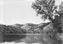
| Description: | Four bluffs are reflected in the back waters of the Mississippi River. A large tree on the right frames the view. |
| Date: | |
|---|---|
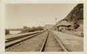
| Description: | View down railroad tracks running along the Mississippi River past a depot. Men are walking near the depot. Caption reads: "C.B.&O. Yards, Lynxville, Wis." |
| Date: | |
|---|---|
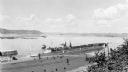
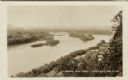
| Description: | Elevated view of the Mississippi River at Lynxville. Railroad tracks are running alongside the shoreline. Caption reads: "Looking N.W. from Lynxville, Wis.... |
If you didn't find the material you searched for, our Library Reference Staff can help.
Call our reference desk at 608-264-6535 or email us at: