 Filter: Categories of Wisconsin Historical Images
Filter: Subject of Mississippi River
Filter: Creator Name of Unknown
Filter: Categories of Wisconsin Historical Images
Filter: Subject of Mississippi River
Filter: Creator Name of Unknown

| Date: | 1918 |
|---|---|
| Description: | View from shoreline of three men standing in the water at Mechanic's Rock on the Mississippi River. |
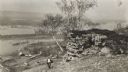
| Date: | 1915 |
|---|---|
| Description: | Elevated view of the Mississippi River from a bluff. There is a farm and other houses along the shoreline, and in the foreground a boy stands on the bluff ... |

| Date: | 1850 |
|---|---|
| Description: | This map of Cassville shows plat of town, roads, and the Mississippi River. Relief is shown by hachures. The map includes an inset map of a Plat of townshi... |

| Date: | 1850 |
|---|---|
| Description: | This map of Cassville shows plat of the town, roads, landings and public wharfs and the Mississippi River. |

| Date: | 1893 |
|---|---|
| Description: | This map of La Crosse shows wards 1-20, streets, railroads, the Inter State Fair Grounds, islands, and the Mississippi River. Relief is shown by hachures. ... |

| Date: | 1940 |
|---|---|
| Description: | This map of La Crosse shows different types of land zoning: residence, multiple dwelling, local business, commercial, light industrial, heavy industrial, w... |

| Date: | 1900 |
|---|---|
| Description: | This map of La Crosse shows twenty wards, some rural lots with acreages, streets, railroads, depots, bridges, cemeteries, parks, schools, islands, and the ... |

| Date: | 1900 |
|---|---|
| Description: | Elevated view of a landscape from the bluffs along the Mississippi River, over Lake Pepin, looking toward Lake City. |

| Date: | 1900 |
|---|---|
| Description: | The map is watercolor, pencil, and ink on tracing cloth and shows plats of both cities, local streets, railroads, mills, township divisions, bridges, and p... |

| Date: | 1895 |
|---|---|
| Description: | Elevated view from bluffs, looking north-east toward Lake City, Minnesota and Lake Pepin of the Mississippi River. |

| Date: | 04 09 1936 |
|---|---|
| Description: | The Buffalo Head, a 'native' stone sculpture by the Mississippi River at the junction of Flint Ledge and Indian trails in Wyalusing State Park. The verso... |

| Date: | 1936 |
|---|---|
| Description: | Four men are building the wall at Signal Point Lookout in Wyalusing State Park. They are part of Works Progress Administration (WPA) Project #8656-8. Th... |

| Date: | 1972 |
|---|---|
| Description: | Before or after a Minnesota vs. Wisconsin Democrats softball game. Congressman David Obey holds up a concept rendering the future Richard I. Bong Memorial ... |

| Date: | 1899 |
|---|---|
| Description: | This map is a folded insert from the pamphlet "Yesterday and Today : A History." The map features the North-Western Line with labeled railway tracks and st... |

| Date: | 1882 |
|---|---|
| Description: | This map is ink on cardboard and shows the location of military forts over the course of years. Also shown are points of interest, streets, the Mississippi... |

| Date: | 1800 |
|---|---|
| Description: | This map is ink and watercolor on paper and shows the main channel and sand bars in the Mississippi River between villages. |

| Date: | 1882 |
|---|---|
| Description: | This map is ink and watercolor on paper and shows numbered plots, the public square, streets, Lake St. Croix and the Mississippi River. |

| Date: | 1838 |
|---|---|
| Description: | This map is a development plat that shows street names, numbered blocks and lots, and small farm lot owners. Included on the right of the map is a large am... |

| Date: | 1828 |
|---|---|
| Description: | This plat map is pen-and-ink and shows landowners, the Mississippi River, the Marais de St. Friole, Fort Crawford, the town commons, and the Village of St.... |

| Date: | 1851 |
|---|---|
| Description: | This map shows labeled counties in Wisconsin and unlabeled county in Michigan. It includes Door County, which was established 1851, but lacks Kewaunee Coun... |
If you didn't find the material you searched for, our Library Reference Staff can help.
Call our reference desk at 608-264-6535 or email us at: