| Date: | 1882 |
|---|---|
| Description: | This map is ink on cardboard and shows the location of military forts over the course of years. Also shown are points of interest, streets, the Mississippi... |

| Date: | 1882 |
|---|---|
| Description: | This map is ink and watercolor on paper and shows numbered plots, the public square, streets, Lake St. Croix and the Mississippi River. |

| Date: | 1838 |
|---|---|
| Description: | This map is a development plat that shows street names, numbered blocks and lots, and small farm lot owners. Included on the right of the map is a large am... |

| Date: | 1829 |
|---|---|
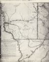
| Description: | This map shows waterways, trails, settlements, Indian villages, and boundaries. The map includes text in the lower left with excerpts from Indian land trea... |

| Date: | 1910 |
|---|---|
| Description: | This map shows the Soo Line railroad and Arpin Hardwood Lumber Company lands in red. The top margin of the map reads: "Wisconsin, the safest state in the U... |

| Date: | 1868 |
|---|---|
| Description: | This map includes a table of estimated costs "by Brev. Maj. Gen. G.K. Warren Maj. U.S.E., of improvement of Wis. River from his survey of 1867." Included a... |

| Date: | |
|---|---|
| Description: | View across Mississippi River towards Maiden Rock. Railroad tracks are in the foreground. |

| Date: | |
|---|---|
| Description: | Illustration of Fort Armstrong on Rock Island, looking from opposite shoreline. There is a barge and other boats on the Mississippi River in front of the f... |

| Date: | 1776 |
|---|---|
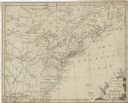
| Description: | Map of the American colonies and land east of the Mississippi River. Prominent cities, forts, Native American land, mountains, rivers and lakes are all sho... |

| Date: | 1782 |
|---|---|
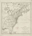
| Description: | Map of America east of the Mississippi River. It shows regions, state boundaries extending to the Mississippi River, cities, forts, Native American lands, ... |

| Date: | 1755 |
|---|---|
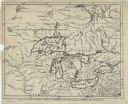
| Description: | Map of the Great Lakes region during the French and Indian War. It shows in great detail the territories, borders and boundary lines, Native American tribe... |

| Date: | 1905 |
|---|---|
| Description: | Aerial view of Fountain City and the Mississippi River. Caption reads: "Fountain City, Wis." |

| Date: | 1905 |
|---|---|
| Description: | View of Fountain City from the Mississippi River. There is a steamer at the dock on the far shoreline. Hills in the background are reflected in the water. |

| Date: | 1910 |
|---|---|
| Description: | Elevated view of Fountain City, with the Mississippi River on the right, and hills in the background on the left. Caption reads: "Fountain City, Wis." |

| Date: | |
|---|---|
| Description: | Colorized view of an elevated view of the brewery beside the Mississippi River. Caption reads: "G. Heilman Brewing Co., La Crosse, Wis." |

| Date: | 1908 |
|---|---|
| Description: | View across the Mississippi River towards the city of La Crosse. Two riverboats are at the river's edge. Caption reads: "River Front and Harbor, La Crosse,... |

| Date: | |
|---|---|
| Description: | A bathing beach on an island near a bridge, with people in the water and on the beach within an enclosed area. A canoe and rowboat are pulled up on the sho... |

| Date: | |
|---|---|
| Description: | Illustration of a fish hatchery on the Mississippi River. A steamboat is on the left near a bridge. Caption reads: "Fish Hatchery, La Crosse, Wis." |

| Date: | |
|---|---|
| Description: | Hand-colored view from the shoreline towards a lumber raft. Caption reads: "Steamer Kit Carson Towing Largest Lumber Raft ever taken down the Mississippi R... |

| Date: | |
|---|---|
| Description: | View from shoreline towards the paddle steamer "G.W. Hill" on the Mississippi River. Caption reads: "Steamer G.W. Hill taking excursion out of La Crosse, W... |
If you didn't find the material you searched for, our Library Reference Staff can help.
Call our reference desk at 608-264-6535 or email us at: