 Filter: Categories of Wisconsin Historical Images
Filter: Subject of Mines and mineral resources
Filter: Categories of Wisconsin Historical Images
Filter: Subject of Mines and mineral resources

| Date: | 1890 |
|---|---|
| Description: | This late 19th century map shows mining companies' lands and miscellaneous properties in the towns of Cady and Springfield in southeastern Saint Croix Coun... |

| Date: | 1886 |
|---|---|
| Description: | This map of Ashland County, Wisconsin, which at the time included part of present-day Iron County, also covers portions of Vilas County, Wisconsin, then pa... |

| Date: | 1887 |
|---|---|
| Description: | This map shows mining properties in the Gogebic Range between Atkins Lake, in Sawyer County, Wisconsin, on the west and Lake Gogebic, Michigan, on the east... |

| Date: | 1952 |
|---|---|
| Description: | This 1952 map of the northern parts of Bayfield and Douglas counties, Wisconsin, shows points established by E.T. Sweet in 1877, road points confirmed by S... |

| Date: | 1889 |
|---|---|
| Description: | This 1889 map of Douglas County, Wisconsin, shows the township and range grid, towns, sections, cities and villages, roads, existing and proposed railroads... |

| Date: | 1892 |
|---|---|
| Description: | This 1892 map of Douglas County, Wisconsin, shows the township and range grid, towns, sections, cities and villages, roads, railroads, trails, lakes and st... |

| Date: | 1899 |
|---|---|
| Description: | This 1899 map of Douglas County, Wisconsin, shows the township and range grid, towns, sections, cities, villages and railroad stations, mines, roads, railr... |
| Date: | |
|---|---|
| Description: | This map, based on an 1858 survey, shows the lead vein and the Western Wisconsin Mining Company's mine shafts in a section in the Town of New Diggings, Laf... |

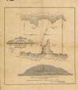
| Date: | 1864 |
|---|---|
| Description: | This map is pen and watercolor on paper and shows profile and geological formation of Blue Mound and location of Arnold’s Hotel and Brigham Lead Mines. |

| Date: | 1921 |
|---|---|
| Description: | Relief shown by contours and spot heights. Includes inset location map. "Contour interval 10 feet." "Advance sheet, subject to correction." "Surveyed in 19... |
| Date: | |
|---|---|
| Description: | Group portrait of workers posing outside a mine, probably in Hurley, Wisconsin. Three young boys stand behind the group among stacks of logs. |
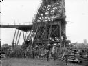
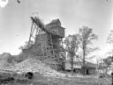
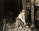
| Date: | |
|---|---|
| Description: | Exterior view of James Mine with a field and fence in the foreground. Tram tracks lead from the tall building to large piles of rocks. There are steep stai... |
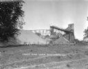
| Date: | 1925 |
|---|---|
| Description: | Exterior view of the Copeland Mine. Entry building, with tram tracks suspended high on scaffolding and piles of rocks below. |
| Date: | 1917 |
|---|---|
| Description: | Betty Sherwin, played by Fannie Ward with her rock pick in hand, searches her inherited mine for gold in a scene still for the silent comedy "Betty to the ... |

| Date: | 02 1898 |
|---|---|
| Description: | Sanborn map of Hurley featuring the Montreal Mining Company. |

| Date: | 11 1905 |
|---|---|
| Description: | Sanborn map of Hurley including mining features. |
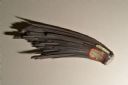
| Date: | 11 12 2013 |
|---|---|
| Description: | A hematite fan, approximately six inches in length, from the mineral collection of Ferdinand Hotz at the University of Wisconsin Geology Museum. This speci... |
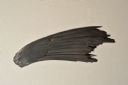
| Date: | 11 12 2013 |
|---|---|
| Description: | A hematite fan, approximately six inches in length, from the mineral collection of Ferdinand Hotz at the University of Wisconsin Geology Museum. This speci... |
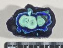
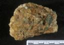
| Date: | 11 12 2013 |
|---|---|
| Description: | A cut and polished azurite malachite nodule from the mineral collection of Ferdinand Hotz at the University of Wisconsin Geology Museum. Azurite and malach... |
| Date: | 11 12 2013 |
|---|---|
| Description: | A specimen of emerald in matrix from the mineral collection of Ferdinand Hotz at the University of Wisconsin Geology Museum. |
If you didn't find the material you searched for, our Library Reference Staff can help.
Call our reference desk at 608-264-6535 or email us at: