Filter: Categories of Wisconsin Historical Images
Filter: Subject of Mines and mineral resources
Filter: Categories of Wisconsin Historical Images
Filter: Subject of Mines and mineral resources

| Date: | 1917 |
|---|---|
| Description: | A geological survey map that shows the sedimentary and igneous deposits in southeastern Wisconsin and south central Wisconsin, as well as the limits of gla... |
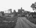
| Date: | 1925 |
|---|---|
| Description: | View down road leading up to the Cokerville Mine. Two horses pulling a wagon are near the road, and automobiles are parked on the right near a building wit... |

| Date: | 1855 |
|---|---|
| Description: | This map shows the township survey grid and identifies counties, named towns, rivers, lakes, railroads, plank roads, mines, and the Menomonee Reservation. ... |

| Date: | 1872 |
|---|---|
| Description: | This map, which includes eastern Iowa, northern Illinois and a portion of Michigan's Upper peninsula, shows the township survey grid and identifies countie... |

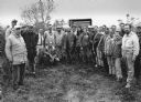
| Date: | 1924 |
|---|---|
| Description: | The Blackstone Mine property and mining equipment. |

| Date: | 1900 |
|---|---|
| Description: | Interior of a lead mine. The five miners are holding candles or lanterns. |
| Date: | 02 11 1925 |
|---|---|
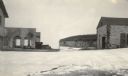
| Description: | View of the large abandoned furnace complex, left, company store, far right, and blacksmith shop behind the company store, on the site of the Jackson Iron ... |
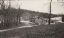
| Date: | 02 1925 |
|---|---|
| Description: | Workers' houses stand in front of the Fayette Tourists Lodge. After the Jackson Iron Company left in 1891, Fayette became a tourist destination and is now ... |
| Date: | 02 1925 |
|---|---|
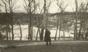
| Description: | An unidentified man looks across Snail Shell Harbor at the remains of the Jackson Iron Company works. The large furnace complex is visible through the tree... |
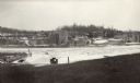
| Date: | 02 1925 |
|---|---|
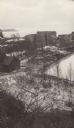
| Description: | Elevated view of the abandoned Jackson Iron Company furnace complex at Fayette, on the shore of Snail Shell Harbor. Lake Michigan is in the background. |
| Date: | 02 1925 |
|---|---|
| Description: | Dolomite cliffs along Snail Shell Harbor are seen in the background between the ruined buildings of the company store, left, and the machine shop on the gr... |

| Date: | 11 1996 |
|---|---|
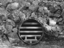
| Description: | "What was a thriving iron ore mine at Neda is now home to some 500,000 bats. The steel cage keeps humans out, but allows access for the bats." |
| Date: | 11 1996 |
|---|---|
| Description: | "A 90-foot-long culvert will serve as an entrance for researchers." |
| Date: | 11 1996 |
|---|---|
| Description: | "The Neda mine has four miles of corridors over about 22 arches." |

| Date: | 11 1996 |
|---|---|
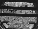
| Description: | "This photo was taken deep in the Neda mine where conditions are monitored closely." |

| Date: | 1866 |
|---|---|
| Description: | A map of Lafayette County, Wisconsin, showing the townships and ranges, sections, towns, villages, stream and rivers, mounds, mineral deposits and the Mine... |

| Date: | 1858 |
|---|---|
| Description: | This 1858 map shows mine shafts, lead veins, and topography on the property of the New Diggings and Shullsburg Mining Company in Section 5 of Township 1 N.... |

| Date: | 1836 |
|---|---|
| Description: | This early to mid-19th century map shows the township and range system, sections, landownership, furnaces, lead mines, copper mines, and roads in the vicin... |
If you didn't find the material you searched for, our Library Reference Staff can help.
Call our reference desk at 608-264-6535 or email us at: