Filter: Categories of Wisconsin Historical Images
Filter: Subject of Mines and mineral resources
Filter: Year of 1900-1999
Filter: Categories of Wisconsin Historical Images
Filter: Subject of Mines and mineral resources
Filter: Year of 1900-1999

| Date: | 1952 |
|---|---|
| Description: | This 1952 map of the northern parts of Bayfield and Douglas counties, Wisconsin, shows points established by E.T. Sweet in 1877, road points confirmed by S... |

| Date: | 1921 |
|---|---|
| Description: | Relief shown by contours and spot heights. Includes inset location map. "Contour interval 10 feet." "Advance sheet, subject to correction." "Surveyed in 19... |
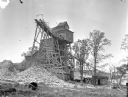
| Date: | 1925 |
|---|---|
| Description: | Exterior view of the Copeland Mine. Entry building, with tram tracks suspended high on scaffolding and piles of rocks below. |
| Date: | 1917 |
|---|---|
| Description: | Betty Sherwin, played by Fannie Ward with her rock pick in hand, searches her inherited mine for gold in a scene still for the silent comedy "Betty to the ... |

| Date: | 11 1905 |
|---|---|
| Description: | Sanborn map of Hurley including mining features. |
| Date: | 05 02 1910 |
|---|---|
| Description: | The postcard shows billowing smoke from the Hurley, Wisconsin Windsor mine shaft. Two men who were in the mine at the time lost their lives. A group of boy... |
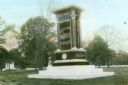
| Date: | 1910 |
|---|---|
| Description: | Hand-colored lantern slide of the Indiana Monument at the Andersonville National Cemetery. The monument was made of Montello granite at a cost of $10,000 i... |
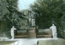
| Date: | 1910 |
|---|---|
| Description: | Hand-colored lantern slide of the Illinois Memorial at Andersonville National Cemetery. A bronze sculpture depicting Columbia, Youth and a Maiden is mounte... |
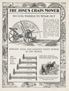
| Date: | 1900 |
|---|---|
| Description: | Advertisement from catalog featuring an illustration of the Jones Chain Mower, and a man using it in a field with a team of horses. Around the border are i... |

| Date: | 06 06 1977 |
|---|---|
| Description: | Original caption reads: "(Photo#TF-1539) -- Diesel engine of International Scout Terra pickup at Morton Salt Company's mine at Grand Saline, Tex., must be ... |

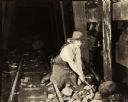
| Date: | 06 06 1977 |
|---|---|
| Description: | Original caption reads: "(Photo #TF-1540) -- Miner (foreground) at Morton Salt Company's operation near Grand Saline, Tex., services helmet lights as Mine ... |
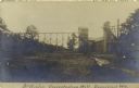
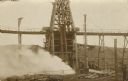
| Date: | 09 30 1907 |
|---|---|
| Description: | Photographic postcard view of the McKinley Concentrating Mill. Caption reads: "McKinley Concentrating Mill, Dodgeville, Wis." |
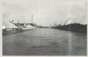
| Date: | 12 16 1957 |
|---|---|
| Description: | View across water, with cranes among piles of coal along the right, and among piles of other materials on the left. Smoke is in the distance on the right, ... |

| Date: | 12 17 1957 |
|---|---|
| Description: | View of icy Lake Michigan from Ogden Street Bridge. There are piles of coal on the left and right, and what may be a jetty in the far distance. |

| Date: | 1906 |
|---|---|
| Description: | This topographical map shows the Little Platte River, shafts, test-pits, old workings, contour lines of Galena limestone elevation, railroads, and building... |

| Date: | 1969 |
|---|---|
| Description: | This map shows ghost towns, Indian reservations, lakes, railroads, and rivers. Ghost towns are numbered and listed in a corresponding index. |

| Date: | 1923 |
|---|---|
| Description: | This map shows major cities surrounding the Great Lakes. Portions of Minnesota, Iowa, Illinois, Indiana, Ohio, Michigan, New York, Vermont, Massachusetts,C... |

| Date: | 1923 |
|---|---|
| Description: | This map shows the movement from coalfields in Ohio, Pennsylvania, West Virginia, Kentucky, and part of Virginia to Lake Erie. Quantities of coal are label... |
If you didn't find the material you searched for, our Library Reference Staff can help.
Call our reference desk at 608-264-6535 or email us at: