 Filter: Categories of Wisconsin Historical Images
Filter: Subject of Mines and mineral resources
Filter: Year of 1900-1999
Filter: Type of Map or Atlas
Filter: Categories of Wisconsin Historical Images
Filter: Subject of Mines and mineral resources
Filter: Year of 1900-1999
Filter: Type of Map or Atlas

| Date: | 1917 |
|---|---|
| Description: | A geological survey map that shows the sedimentary and igneous deposits in southeastern Wisconsin and south central Wisconsin, as well as the limits of gla... |

| Date: | 1952 |
|---|---|
| Description: | This 1952 map of the northern parts of Bayfield and Douglas counties, Wisconsin, shows points established by E.T. Sweet in 1877, road points confirmed by S... |

| Date: | 1921 |
|---|---|
| Description: | Relief shown by contours and spot heights. Includes inset location map. "Contour interval 10 feet." "Advance sheet, subject to correction." "Surveyed in 19... |

| Date: | 11 1905 |
|---|---|
| Description: | Sanborn map of Hurley including mining features. |

| Date: | 1906 |
|---|---|
| Description: | This topographical map shows the Little Platte River, shafts, test-pits, old workings, contour lines of Galena limestone elevation, railroads, and building... |

| Date: | 1969 |
|---|---|
| Description: | This map shows ghost towns, Indian reservations, lakes, railroads, and rivers. Ghost towns are numbered and listed in a corresponding index. |

| Date: | 1923 |
|---|---|
| Description: | This map shows major cities surrounding the Great Lakes. Portions of Minnesota, Iowa, Illinois, Indiana, Ohio, Michigan, New York, Vermont, Massachusetts,C... |

| Date: | 1923 |
|---|---|
| Description: | This map shows the movement from coalfields in Ohio, Pennsylvania, West Virginia, Kentucky, and part of Virginia to Lake Erie. Quantities of coal are label... |

| Date: | 1923 |
|---|---|
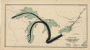
| Description: | This map shows the movement of iron ore in areas of Ohio, Pennsylvania, New York, New Jersey, Lake Erie, Lake Ontario, and parts of Ontario, Maryland, and ... |

| Date: | 1923 |
|---|---|
| Description: | This map shows the movement of iron ore in parts of Minnesota, Wisconsin, and the Upper Peninsula of Michigan, and includes parts of Lake Superior, Green B... |

| Date: | 1923 |
|---|---|
| Description: | This map shows the movement of iron ore along the Great Lakes. Portions of Minnesota, Iowa, Wisconsin, Illinois, Indiana, Ohio, Michigan, New York, Vermont... |
| Date: | 1923 |
|---|---|
| Description: | This map shows the movement of anthracite coal throughout Minnesota, Wisconsin, Ontario, Quebec, Michigan, Illinois, Indiana, and New York. Iowa, Vermont,... |

| Date: | 12 1903 |
|---|---|
| Description: | This manuscript blueprint map shows streets and lots and includes certifications in the left margin. Horizontal streets top to bottom are: Iroquois, Main, ... |

| Date: | 1937 |
|---|---|
| Description: | Pictorial map showing historical events and locations within the state of Wisconsin, as well as waterways and counties. Original caption on the bottom marg... |

| Date: | 1985 |
|---|---|
| Description: | This map shows mining, White River, Silver Creek, Bad River, Agogic Lake, Chequamegon Bay, smaller lakes, the Bad River Indian Reservation, and communities... |

| Date: | 1903 |
|---|---|
| Description: | This blue line print shows quartzite areas, mines, railroads, and roads. The map covers townships 11-13 north, ranges 4-8 east, in parts of Sauk and Columb... |

| Date: | 1904 |
|---|---|
| Description: | This blue line print map includes 4 cross sections with relief shown by contours and spot heights. The topography was taken from the United States Geologic... |
| Date: | 1978 |
|---|---|
| Description: | A map showing allotments of American Indian tribes in Ottawa County, Oklahoma. On the left side is a listing of Lead & Zinc Mines. |
If you didn't find the material you searched for, our Library Reference Staff can help.
Call our reference desk at 608-264-6535 or email us at: