 Filter: Categories of Wisconsin Historical Images
Filter: Subject of Mines and mineral resources
Filter: Year of 1800-1899
Filter: Year of 1840-1849
Filter: Categories of Wisconsin Historical Images
Filter: Subject of Mines and mineral resources
Filter: Year of 1800-1899
Filter: Year of 1840-1849

| Date: | 1849 |
|---|---|
| Description: | Geological map of the mineral region around Lake Superior, including portions of Michigan, Wisconsin, Iowa and Illinois. |

| Date: | 1847 |
|---|---|
| Description: | A hand-colored map that shows the area south and east of the Wisconsin and Fox Rivers, as well as a few landmarks just north of that area. The township gri... |

| Date: | 1842 |
|---|---|
| Description: | This map shows portions of northern Illinois and Wisconsin surveyed by the map's creation. It shows county lines and university land, and depicts lead and ... |

| Date: | 1846 |
|---|---|
| Description: | This map shows the counties and towns in existence at the time as well as lead and copper mines. |

| Date: | 1848 |
|---|---|
| Description: | This map by Increase Lapham shows the township and range system in southern and eastern Wisconsin as well as along the Wisconsin River in present-day Marat... |

| Date: | 1849 |
|---|---|
| Description: | Published a year after Wisconsin entered statehood, this map shows the counties and towns in existence at the time - mainly in southern/southeastern Wiscon... |
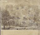
| Date: | 1845 |
|---|---|
| Description: | Drawing of Shullsburg. Text at bottom reads: "Smelting lead ore in log furnaces. Scene in Gratiots Grove at Shullsburg, Wis. in 1845-6. Drawn from life. By... |
If you didn't find the material you searched for, our Library Reference Staff can help.
Call our reference desk at 608-264-6535 or email us at:
