 Filter: Categories of Wisconsin Historical Images
Filter: Subject of Mines and mineral resources
Filter: Year of 1800-1899
Filter: Categories of Wisconsin Historical Images
Filter: Subject of Mines and mineral resources
Filter: Year of 1800-1899

| Date: | 1871 |
|---|---|
| Description: | This map shows railroads, canals, towns and some lighthouses. Areas of the company lands proper, tin, iron, gold & silver, silver islet, and lead are color... |

| Date: | 1857 |
|---|---|
| Description: | This map shows lot numbers, lot dimensions (in chains and links), and a mineral reservation for use of proprietors. Includes certifications signed in Sept.... |

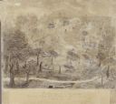
| Date: | 1864 |
|---|---|
| Description: | This map is pen and watercolor on paper and shows a profile and the geological formation of Blue Mound. Also shown is the location of Arnold's Hotel and Br... |

| Date: | 1866 |
|---|---|
| Description: | A colorful map of Gilpin County, the central gold region of Colorado, surveyed by Charles W. Morse and George Hill. |

| Date: | 1805 |
|---|---|
| Description: | Map of the United States. It shows the states, cities, towns, Native American land, mountains, lakes, and rivers. Tennessee, Kentucky, and Ohio are labeled... |

| Date: | 1800 |
|---|---|
| Description: | Map of the United States. It shows the states, including Tennessee, cities, towns, Native American land, mountains, lakes, and rivers. Lead mines appear ju... |
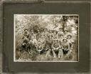
| Date: | 1895 |
|---|---|
| Description: | Outdoor group portrait of the miners who work at Optimal Mine. They are seated outdoors on the grass, and are wearing work clothes and hats. |
| Date: | 1845 |
|---|---|
| Description: | Drawing of Shullsburg. Text at bottom reads: "Smelting lead ore in log furnaces. Scene in Gratiots Grove at Shullsburg, Wis. in 1845-6. Drawn from life. By... |

| Date: | 1838 |
|---|---|
| Description: | Drawing of Shullsburg. There is a numbered key on the left that reads, at top: "Explanation. Nos. Denote present Site." Streets are named on the map and ma... |
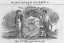
| Date: | 1857 |
|---|---|
| Description: | Great Seal of the State of Wisconsin as found in American Farmer, vol. 9. |
If you didn't find the material you searched for, our Library Reference Staff can help.
Call our reference desk at 608-264-6535 or email us at: