 Filter: Categories of Wisconsin Historical Images
Filter: Subject of Mines and mineral resources
Filter: Subject of formations (geology)
Filter: Categories of Wisconsin Historical Images
Filter: Subject of Mines and mineral resources
Filter: Subject of formations (geology)
| Date: | 1900 |
|---|---|
| Description: | Visitors, dressed in their Sunday best, contrast with the rough garb of the miners. Left to right, miners were: Charles Kanass, Robert "Beaver" Smith (hold... |
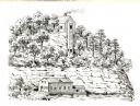
| Date: | 1836 |
|---|---|
| Description: | The shot tower at Tower Hill State Park. |
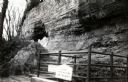
| Date: | 1945 |
|---|---|
| Description: | The top of the shot tower shaft with the entrance. The sign on the railing reads: "Do Not Throw Anything Down This Shaft". |
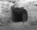
| Date: | 1945 |
|---|---|
| Description: | The tunnel at the bottom of the shot tower shaft. |
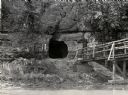
| Date: | 1950 |
|---|---|
| Description: | View across river towards the tunnel leading to the bottom of the shot tower shaft at Tower Hill State Park. There is a rustic bridge on the right leading ... |
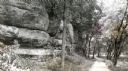
| Date: | 1945 |
|---|---|
| Description: | Tower Hill State Park trail leading to the top of the shot tower shaft. |
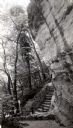
| Date: | 1945 |
|---|---|
| Description: | Tower Hill State Park trail to the top of the shot tower shaft. |
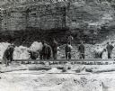
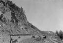
| Date: | 1945 |
|---|---|
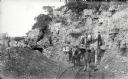
| Description: | A group of men laying rails at Hawkins Mine while a man in the background is using surveying equipment near the base of a cliff face. |

| Date: | 09 1910 |
|---|---|
| Description: | Men carrying dead lambs back to the Leighton-Wyoming mining camp. |
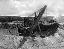
| Date: | |
|---|---|
| Description: | A 300 ton steam shovel scooping iron ore at the Hull Rust Mahoning Mine, the world's largest open pit iron ore mine. |
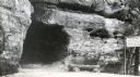
| Date: | 1920 |
|---|---|
| Description: | Entrance of the tunnel to the bottom of the shot tower. There is graffiti around the entrance. |

| Date: | 1847 |
|---|---|
| Description: | A hand-colored map that shows the area south and east of the Wisconsin and Fox Rivers, as well as a few landmarks just north of that area. The township gri... |

| Date: | 1842 |
|---|---|
| Description: | This map shows portions of northern Illinois and Wisconsin surveyed by the map's creation. It shows county lines and university land, and depicts lead and ... |

| Date: | 1906 |
|---|---|
| Description: | This topographical map shows the Little Platte River, shafts, test-pits, old workings, contour lines of Galena limestone elevation, railroads, and building... |

| Date: | 1886 |
|---|---|
| Description: | This map shows north and south ore veins, landownership, railroads, rivers, and township grid in parts of Ashland County, Wis. and Ontonagon County, Mich. ... |
| Date: | 07 1936 |
|---|---|
| Description: | A worker is pulling a wheelbarrow behind him while walking alongside a narrow gauge railroad track at the south end of the East Bluff near Devil's Lake. Em... |

| Date: | |
|---|---|
| Description: | Two men are standing in front of the entrance to a mine. Vertical beams are just inside the entrance. The man on the left has a cloth sack draped over his ... |
If you didn't find the material you searched for, our Library Reference Staff can help.
Call our reference desk at 608-264-6535 or email us at:
