 Filter: Categories of Wisconsin Historical Images
Filter: Subject of Mines and mineral resources
Filter: Creator Name of Unknown
Filter: Categories of Wisconsin Historical Images
Filter: Subject of Mines and mineral resources
Filter: Creator Name of Unknown
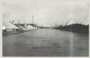
| Date: | 12 16 1957 |
|---|---|
| Description: | View across water, with cranes among piles of coal along the right, and among piles of other materials on the left. Smoke is in the distance on the right, ... |

| Date: | 12 17 1957 |
|---|---|
| Description: | View of icy Lake Michigan from Ogden Street Bridge. There are piles of coal on the left and right, and what may be a jetty in the far distance. |
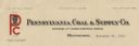
| Date: | |
|---|---|
| Description: | Letterhead of the Pennsylvania Coal & Supply Company, with the company trademark: the initials "P" and "C" printed in red ink, and a head and shoulders ima... |

| Date: | 1857 |
|---|---|
| Description: | This map shows lot numbers, lot dimensions (in chains and links), and a mineral reservation for use of proprietors. Includes certifications signed in Sept.... |

| Date: | 1903 |
|---|---|
| Description: | This blue line print shows quartzite areas, mines, railroads, and roads. The map covers townships 11-13 north, ranges 4-8 east, in parts of Sauk and Columb... |

| Date: | 1782 |
|---|---|
| Description: | Map of the West Indies and south eastern North America, remarkably detailed, showing cities, mountains, rivers, lakes, mines, plantations, forts, banks, an... |

| Date: | 1800 |
|---|---|
| Description: | Map of the United States. It shows the states, including Tennessee, cities, towns, Native American land, mountains, lakes, and rivers. Lead mines appear ju... |

| Date: | 1720 |
|---|---|
| Description: | Map showing the course of the Mississippi River from the Gulf of Mexico up past Lake Superior into Canada. It shows the towns, Native American tribes and l... |
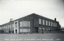
| Date: | |
|---|---|
| Description: | View of the Cary Mine office building. Caption reads: "Cary Mine Office & Machine Shop, Hurley, Wis. |

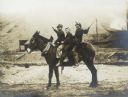
| Date: | |
|---|---|
| Description: | Stereograph of the side view of a mine. Several horse-drawn wagons are waiting for loads with workmen. Hills of soil surround a flat area, and on the horiz... |

| Date: | |
|---|---|
| Description: | Stereograph of an elevated view of a mining operation. Men are posing on the head frame/gallows frame over the pit. One man is perching on the top of the g... |

| Date: | |
|---|---|
| Description: | Stereograph of four men standing with ore carts. Two more men are standing on the left near a pile of square timbers, and another man is standing on the ri... |
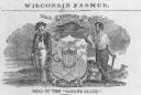
| Date: | 1857 |
|---|---|
| Description: | Great Seal of the State of Wisconsin as found in American Farmer, vol. 9. |
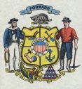
| Date: | |
|---|---|
| Description: | 1881 version of the Coat of Arms of the State of Wisconsin. |
| Date: | 1901 |
|---|---|
| Description: | Group portrait of three boys sitting on a donkey. |

| Date: | 1907 |
|---|---|
| Description: | Elevated view of Hurley, WI and nearby industrial sites (Scott & Howe Lumber Co. Mill, Ashland Mine). Inventory reads: "Looking west and a little south ove... |

| Date: | 1905 |
|---|---|
| Description: | Slightly elevated view of the border between Hurley, WI and Ironwood, MI. Caption reads: "Looking east from Hurley side of Montreal River near Silver Stree... |
If you didn't find the material you searched for, our Library Reference Staff can help.
Call our reference desk at 608-264-6535 or email us at:
