Filter: Categories of Wisconsin Historical Images
Filter: Subject of Michigan, Lake
Filter: Year of 1900-1999
Filter: Year of 1900-1909
Filter: Subject of land
Filter: Categories of Wisconsin Historical Images
Filter: Subject of Michigan, Lake
Filter: Year of 1900-1999
Filter: Year of 1900-1909
Filter: Subject of land
| Date: | 1900 |
|---|---|
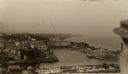
| Description: | Elevated view of the Pabst Whitefish Bay Resort. |
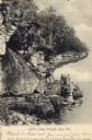
| Date: | 1906 |
|---|---|
| Description: | View of Lover's Leap with a group of people on the rocks near the shoreline under an overhang. Caption reads: "Lovers Leap, Sturgeon Bay, Wis." |

| Date: | 1907 |
|---|---|
| Description: | The Ruins of the old Light House on Plum Island near Sturgeon Bay. Caption at bottom reads: "Ruins of Old Light House on Plum Island," "Made expressly for ... |
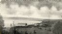
| Date: | 1900 |
|---|---|
| Description: | View across water of a dock and buildings on Lake Michigan. |

| Date: | 1909 |
|---|---|
| Description: | [Lithography] by Poole Bros. Contains descriptive information. Short jaunts for busy people to nearby resorts in Illinois and Wisconsin. |
| Date: | 1909 |
|---|---|
| Description: | Elevated view of town. A person is in the right foreground. Caption reads: "A Glimpse(?) of Port Washington, Wis." |
| Date: | 06 19 1902 |
|---|---|
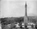
| Description: | Elevated view of the North Point Water Tower at the foot of E. North Avenue. |
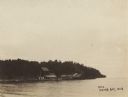
| Date: | 1902 |
|---|---|
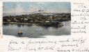
| Description: | Elevated view of island with houses and boathouses and boats along the shoreline. Industrial buildings are in the background, and a sailboat is on the wate... |
| Date: | 1905 |
|---|---|
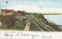
| Description: | Elevated view of people walking on a path by the Whitefish Bay Resort along the lake front. Caption reads: "Whitefish Bay Resort, Milwaukee." |

| Date: | 1905 |
|---|---|
| Description: | A reproduction of the Wisconsin portion of Louis Hennepin's 1698 map showing the location of the Ho-Chunk Tribe, the Hurons, the Illinois as well as other ... |

| Date: | 1900 |
|---|---|
| Description: | A map of Wisconsin, eastern Minnesota and Iowa, northern Iowa, and Michigan’s Upper Peninsula, showing railway lines, with those marked with heavy red line... |

| Date: | 1900 |
|---|---|
| Description: | This map, which shows the state of Wisconsin in 1895, was published as Rand, McNally & Co.'s New business atlas map of Wisconsin. Railroads, counties, citi... |

| Date: | 1900 |
|---|---|
| Description: | A map of Wisconsin, eastern Minnesota and Iowa, and Michigan’s Upper Peninsula, showing the rail lines of the Wisconsin Central Railroad are shown in red, ... |

| Date: | 1908 |
|---|---|
| Description: | A business map of Wisconsin, showing railroads, counties, cities, villages, rivers, and lakes. Additional areas shown in the map include the western portio... |
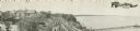
| Date: | 1907 |
|---|---|
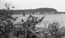
| Description: | View across Fish Creek Harbor to the village of Fish Creek and its pier, with warehouse. On the right is Dr. Weckler's Resort, a large wooden building with... |
| Date: | 1909 |
|---|---|
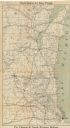
| Description: | This map shows the Chicago and North Western Railway lines in eastern Wisconsin, north to Wausau and Oconto and west to Baraboo and Blue Mounds, and northe... |
| Date: | 09 1900 |
|---|---|
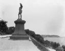
| Description: | View of a statue in Juneau Park, created by American sculptor Anne Whitney in 1887. The statue is a replica of the original which resides in Boston, Massac... |
If you didn't find the material you searched for, our Library Reference Staff can help.
Call our reference desk at 608-264-6535 or email us at: