Filter: Categories of Wisconsin Historical Images
Filter: Subject of Michigan, Lake
Filter: Year of 1900-1999
Filter: County of Sheboygan
Filter: Categories of Wisconsin Historical Images
Filter: Subject of Michigan, Lake
Filter: Year of 1900-1999
Filter: County of Sheboygan

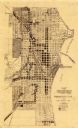
| Date: | 1914 |
|---|---|
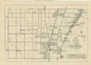
| Description: | This map shows Sheboygan in 1914. The top of the map has the date of "NOV 17 1916" stamped in red ink. The map shows numbered plots and labeled streets, an... |
| Date: | 1965 |
|---|---|
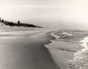
| Description: | The Lake Michigan shoreline in the Kohler-Andrae State Park, named after John Michael Kohler and Terry Andrae. |
| Date: | 1965 |
|---|---|
| Description: | The sand dunes in Kohler-Andrae State Park, named after John Michael Kohler and Terry Andrae. |
| Date: | 1909 |
|---|---|
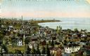
| Description: | Elevated view of town on Lake Michigan. Caption reads: "Sheboygan, Wis. North Point on Lake Michigan." |
| Date: | 1941 |
|---|---|
| Description: | A map shows early settlers by name and date, industries, the Chicago & North Western rail line, roads, and depths and net lines in Lake Michigan. Text prov... |

| Date: | 1934 |
|---|---|
| Description: | This 1930s highway map of Sheboygan County, Wisconsin, shows roads, the township and range grid, towns, sections, cities and villages, and streams, lakes, ... |

| Date: | 1938 |
|---|---|
| Description: | Small child standing on the shoreline of a sandy beach, looking out at the waves, at Terry Andrae State Park on Lake Michigan. |

| Date: | 1921 |
|---|---|
| Description: | This map is part of the survey of the northern and northwestern lakes. The map shows Sheboygan Harbor on the shore of Lake Michigan and the Sheboygan River... |
| Date: | 1935 |
|---|---|
| Description: | This map created by the Sheboygan City Engineer department shows five different types of land use in the city in 1935. A legend in the bottom right corner ... |

| Date: | 1956 |
|---|---|
| Description: | This maps shows voting precincts and polling places as well as wards. Streets and the Sheboygan River are labeled. The bottom right of the map features a l... |

| Date: | 1921 |
|---|---|
| Description: | This map shows Lake Michigan, the Sheboygan River, buildings, streets, churches, industrial yards, and parks. Relief is shown by hachures and depths are sh... |

| Date: | 1915 |
|---|---|
| Description: | This map shows wards, railroads, street railways, streets, lot and block numbers, parks, and hospitals. Also included are manuscript annotations of points ... |

| Date: | 1926 |
|---|---|
| Description: | This map includes a legend in the lower right corner of building heights. Districts marked "A" are 35 foot, districts marked "B" are 45 foot, districts mar... |

| Date: | 1926 |
|---|---|
| Description: | This map includes a legend in the lower right corner of land use. Districts are shown in five different shading for: "A" residential, "B" are residential, ... |

| Date: | 1938 |
|---|---|
| Description: | A child wearing a bathing suit is standing with their feet in shallow water as waves approach the shore. On the reverse of the print is written: "A tiny to... |
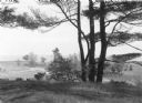
| Date: | 1938 |
|---|---|
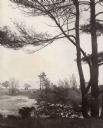
| Description: | View down slope towards a pine tree with three main trunks silhouetted against rolling dunes on the shore of Lake Michigan. |

| Date: | 1970 |
|---|---|
| Description: | A Blue Heron is standing on a breakwater in Lake Michigan. The Sheboygan Breakwater Lighthouse is on the horizon. |
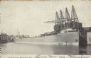
| Date: | 10 17 1906 |
|---|---|
| Description: | Text on front reads: "Harbor View - Sheboygan, Wis." A lake freighter, or "laker" is docked at the harbor. |

| Date: | 1907 |
|---|---|
| Description: | Text on front reads: "Bathing Beach, Sheboygan, Wis." View from water towards a large beach on the Lake Michigan shoreline. There is a crowd on the sand an... |
If you didn't find the material you searched for, our Library Reference Staff can help.
Call our reference desk at 608-264-6535 or email us at: