Filter: Categories of Wisconsin Historical Images
Filter: Subject of Michigan, Lake
Filter: Year of 1900-1999
Filter: Community of Milwaukee
Filter: Year of 1930-1939
Filter: Categories of Wisconsin Historical Images
Filter: Subject of Michigan, Lake
Filter: Year of 1900-1999
Filter: Community of Milwaukee
Filter: Year of 1930-1939

| Date: | 1937 |
|---|---|
| Description: | Bird's-eye view of Milwaukee in 1853 details building features and city layout from southwest. Important buildings are numbered in a silhouette drawing bel... |
| Date: | 1938 |
|---|---|
| Description: | Aerial view of rivers, with Lake Michigan in upper right, train yards, and highway in lower left. |
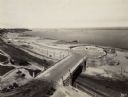
| Date: | 1930 |
|---|---|
| Description: | Elevated view of Lincoln Memorial Drive at the point where it joins Wisconsin Avenue, now the site of the Milwaukee County War Memorial Center. Lake Michig... |
| Date: | 1937 |
|---|---|
| Description: | View down the hill toward the U.S. Coast Guard Station on the left with two communications towers on the Lake Michigan shoreline. Railroad tracks are just ... |
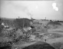
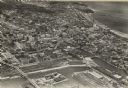
| Date: | 10 28 1938 |
|---|---|
| Description: | Elevated view of a cluster of old dwellings in the center, with broken shacks and rusted cars. In the background are railroad cars, and an industrial area ... |
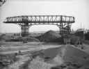
| Date: | 10 28 1938 |
|---|---|
| Description: | Men working near large dredge on Jones Island. Large piles of material are on the ground below the dredge. There is a ship on the right. In the distance a... |
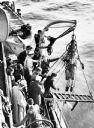
| Date: | 04 10 1937 |
|---|---|
| Description: | On April 10th, 1937, Max Nohl (shown in the dive suit) along with John Craig made a dive on the shipwreck Norland in order to perform another early ... |
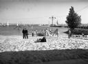
| Date: | 1939 |
|---|---|
| Description: | A beach on Lake Michigan near the Milwaukee Yacht Club. Men, women, and children relax on the beach. In the background many boats are on the water. |

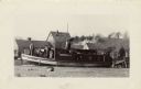
| Date: | 1938 |
|---|---|
| Description: | Two men stand to the rear of a 44-foot fishing boat marked Frank Braeger. The boat was owned by Julius Detlaff and powered by an International PD-80... |
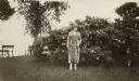
| Date: | 1930 |
|---|---|
| Description: | Alice Holloway standing in front of a flowering rose bush along the shore of Lake Michigan during a trip to Milwaukee to celebrate her engagement. |

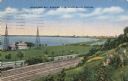
| Date: | 1936 |
|---|---|
| Description: | An elevated view of Milwaukee Harbor with railroad station looking towards Lake Michigan. |

| Date: | 1931 |
|---|---|
| Description: | This map is an advertisement for Milwaukee street cars and motor buses and reads: "Ride the street car or motor bus. Economical, safe, dependable." Include... |

| Date: | 1934 |
|---|---|
| Description: | Map showing the ward boundaries of Milwaukee. Each ward is numbered and boundary streets are labelled. The bottom right corner reads: "CITY ENGINEER'S DEPT... |

| Date: | 1936 |
|---|---|
| Description: | Street map of the City of Milwaukee and surrounding suburbs indicating various mass transit lines. There is an index to Milwaukee streets at the right of t... |

| Date: | 04 04 1934 |
|---|---|
| Description: | Street map of the city of Milwaukee and surrounding communities at a scale of 1 inch to 1200 feet. |
| Date: | 1931 |
|---|---|
| Description: | The Frank Braeger is moored on the shore of Jones Island with steam issuing from the pipe, with the crew posing on the boat. In the background a man... |

| Date: | 1931 |
|---|---|
| Description: | Two smiling fishermen stand before their fishing nets on Jones Island. There are floats attached to one net and a barrel with a jacket on top of it. |

| Date: | 1934 |
|---|---|
| Description: | This map is attached to a cover. Streets, points of interest, the Milwaukee River, and Lake Michigan are labeled. The bottom margin of the map includes a s... |

| Date: | 1930 |
|---|---|
| Description: | This map shows streets, railways, bus lines, railroads, roads, parks, cemeteries, Lake Michigan, and a proposed harbor. Also included is a legend and on th... |
If you didn't find the material you searched for, our Library Reference Staff can help.
Call our reference desk at 608-264-6535 or email us at: