 Filter: Categories of Wisconsin Historical Images
Filter: Subject of Michigan, Lake
Filter: Subject of rivers
Filter: Year of 1900-1999
Filter: Categories of Wisconsin Historical Images
Filter: Subject of Michigan, Lake
Filter: Subject of rivers
Filter: Year of 1900-1999

| Date: | 1914 |
|---|---|
| Description: | This map shows Sheboygan in 1914. The top of the map has the date of "NOV 17 1916" stamped in red ink. The map shows numbered plots and labeled streets, an... |

| Date: | 1927 |
|---|---|
| Description: | Color map, hand-drawn with comic figures engaged in various activities throughout map. Bordered by the river on the left and Lake Michigan on the right, in... |

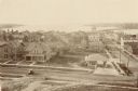
| Date: | 1937 |
|---|---|
| Description: | Bird's-eye view of Milwaukee in 1853 details building features and city layout from southwest. Important buildings are numbered in a silhouette drawing bel... |

| Date: | 1905 |
|---|---|
| Description: | Bird's-eye view of Manitowoc on the shores of Lake Michigan. A map of the northeastern part of the United States at the top indicates Manitowoc's location ... |
| Date: | 1925 |
|---|---|
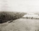
| Description: | Aerial view of Green Bay, including the Jorgensen-Blesch Company building and two bridges. |
| Date: | 1920 |
|---|---|
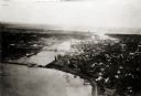
| Description: | Aerial view of with bridges, river, and shoreline. |
| Date: | 1900 |
|---|---|
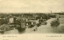
| Description: | Elevated view of east Green Bay harbor with cargo ships, W.W. Cagill Co., and other various industries. |
| Date: | 1910 |
|---|---|
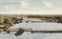
| Description: | Elevated view of the harbor entrance. Caption reads: "Harbor Entrance, Green Bay, Wis." |

| Date: | 1941 |
|---|---|
| Description: | Official highway map of Wisconsin, "the playground of the Midwest," showing the state transportation network prior to World War II. |

| Date: | 1950 |
|---|---|
| Description: | An aerial view of town, showing a major industrial area. |
| Date: | 1910 |
|---|---|
| Description: | Elevated view of various buildings with Sturgeon Bay in the background. |

| Date: | 1910 |
|---|---|
| Description: | Wisconsin Geological and Natural History Survey, by Lawrence Martin reproduced from a model of the state prepared by W.O. Hotchkiss and F.T. Thwaites and m... |

| Date: | 1906 |
|---|---|
| Description: | Polyconic projection. Map made from surveys without spirit level control. Henry Gannett, Chief Topographer. Topography by Van H. Manning and Nat. Tyler, Jr... |

| Date: | 1916 |
|---|---|
| Description: | Southeastern Wisconsin which lies east of Whitewater and south of Port Washington. |
| Date: | 1938 |
|---|---|
| Description: | Aerial view of rivers, with Lake Michigan in upper right, train yards, and highway in lower left. |

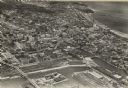
| Date: | 1940 |
|---|---|
| Description: | Aerial view of city, river and harbor. Two smokestacks are on either side of the river mouth. |

| Date: | 1932 |
|---|---|
| Description: | This map includes a distance table, text, and insets maps of, Superior, Ashland, Marinette, Green Bay, Appleton, Manitowoc, Oshkosh, Fond Du Lac, Janesvill... |

| Date: | 1907 |
|---|---|
| Description: | Text on front reads: "Racine, Wis. in 1850." Artist's rendering of the view of the harbor with sailing ships, sailboats, rowboats and canoes. The Main Stre... |

| Date: | 1970 |
|---|---|
| Description: | Aerial view of International Harvester's Wisconsin Steel Works, with a river and Lake Michigan in the background. |
If you didn't find the material you searched for, our Library Reference Staff can help.
Call our reference desk at 608-264-6535 or email us at:
