Filter: Categories of Wisconsin Historical Images
Filter: Subject of Michigan, Lake
Filter: Subject of rivers
Filter: Categories of Wisconsin Historical Images
Filter: Subject of Michigan, Lake
Filter: Subject of rivers

| Date: | 1910 |
|---|---|
| Description: | Wisconsin Geological and Natural History Survey, by Lawrence Martin reproduced from a model of the state prepared by W.O. Hotchkiss and F.T. Thwaites and m... |

| Date: | 1906 |
|---|---|
| Description: | Polyconic projection. Map made from surveys without spirit level control. Henry Gannett, Chief Topographer. Topography by Van H. Manning and Nat. Tyler, Jr... |

| Date: | 1868 |
|---|---|
| Description: | Showing the counties, towns and railroads. Partly colored. Scale: 1 inch = 20 miles. |

| Date: | 1859 |
|---|---|
| Description: | This 1859 railroad map shows counties, cities, rivers and lakes in the entire state of Wisconsin. It includes an inset depicting the railroads in Milwaukee... |

| Date: | 1916 |
|---|---|
| Description: | Southeastern Wisconsin which lies east of Whitewater and south of Port Washington. |

| Date: | |
|---|---|
| Description: | Plan of township no. 3 north, range no. 5 west of the 4th principal meridian. |

| Date: | 1854 |
|---|---|
| Description: | Bird's-eye illustration of Milwaukee. |

| Date: | 1852 |
|---|---|
| Description: | Map reads: "The State of Wisconsin- compiled from the latest authorities". In addition, there is a scale which is six miles for every inch, and a profile o... |

| Date: | |
|---|---|
| Description: | Map reads: "Historic and Scenic Wisconsin — Land of Gathering Waters." In an inset there is a hand-painted depiction of the Wisconsin State Seal. For some ... |

| Date: | 1842 |
|---|---|
| Description: | Map reads: "Wisconsin". The map depicts the counties as of 1842 and the various areas of Indian settlements. The scale is twenty miles for every inch. |

| Date: | 1861 |
|---|---|
| Description: | A map of Wisconsin showing cities, counties, major roads, railroads, and bodies of water. Includes an inset of the vicinity of Milwaukee. |
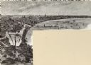
| Date: | |
|---|---|
| Description: | Aerial view looking north of downtown, with the Milwaukee River and Lake Michigan. |
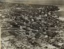
| Date: | 1938 |
|---|---|
| Description: | Aerial view of rivers, with Lake Michigan in upper right, train yards, and highway in lower left. |

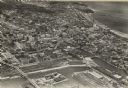
| Date: | 1940 |
|---|---|
| Description: | Aerial view of city, river and harbor. Two smokestacks are on either side of the river mouth. |

| Date: | 1833 |
|---|---|
| Description: | Published in James Smith Buck's, "Pioneer History of Milwaukee". Lake Michigan is on the right, with three rivers that combine at different points and reac... |

| Date: | 1833 |
|---|---|
| Description: | Drawing on a faint grid with Lake Michigan on the right, and the rivers on the left. Labeled is an Indian Village, J. Veiu, S. Juneau, and P. Juneau. Alo... |

| Date: | 1890 |
|---|---|
| Description: | This map shows lakes, railroads, and rivers. An explanation of railroad lines with mileage in Wisconsin and total mileage for 1890 is included. Portions of... |

| Date: | 1932 |
|---|---|
| Description: | This map includes a distance table, text, and insets maps of, Superior, Ashland, Marinette, Green Bay, Appleton, Manitowoc, Oshkosh, Fond Du Lac, Janesvill... |

| Date: | 1907 |
|---|---|
| Description: | Text on front reads: "Racine, Wis. in 1850." Artist's rendering of the view of the harbor with sailing ships, sailboats, rowboats and canoes. The Main Stre... |
If you didn't find the material you searched for, our Library Reference Staff can help.
Call our reference desk at 608-264-6535 or email us at: