 Filter: Categories of Wisconsin Historical Images
Filter: Subject of Michigan, Lake
Filter: Subject of rivers
Filter: Categories of Wisconsin Historical Images
Filter: Subject of Michigan, Lake
Filter: Subject of rivers

| Date: | 1879 |
|---|---|
| Description: | A map of Wisconsin as well as the southeastern most portions of Minnesota and Iowa and the Upper Peninsula of Michigan showing the township grids, railways... |

| Date: | 1879 |
|---|---|
| Description: | A map of Wisconsin showing counties, county seats, cities over 3,000 inhabitants, Lake Michigan steamship routes, railroads completed and projected, rivers... |

| Date: | 1881 |
|---|---|
| Description: | A hand-colored map of Wisconsin that shows counties, cities, towns, villages, railroads, as well as the locations of railroad stations and post offices wit... |

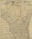
| Date: | 1880 |
|---|---|
| Description: | Map of Wisconsin including the eastern portions on Minnesota, Iowa, northern Illinois, and the western most portion of Michigan’s Upper Peninsula, showing ... |

| Date: | 1881 |
|---|---|
| Description: | A brochure with a map of Wisconsin that also includes information (in English, German, Norwegian, and Swedish) pertaining to the state, such as its timber ... |

| Date: | 1883 |
|---|---|
| Description: | A hand-colored map of Wisconsin showing the nine congressional districts, it also shows the counties, cities, railroads, rivers, and lakes in the state. |

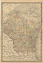
| Date: | 1883 |
|---|---|
| Description: | A hand-colored map of Wisconsin showing counties, cities, villages, railroads, lakes, and rivers in the state. The map also includes the eastern portions o... |
| Date: | 1885 |
|---|---|
| Description: | A hand-colored map of Wisconsin that also includes eastern Minnesota and Iowa, northern Illinois, and the Upper Peninsula of Michigan showing the counties,... |

| Date: | 1885 |
|---|---|
| Description: | A hand-colored map of Wisconsin showing the railroads, counties, cities, towns, rivers, and lakes in the state. Also included in the map are the eastern po... |
| Date: | 1888 |
|---|---|
| Description: | A cloth mounted, hand-colored map of Wisconsin depicting the rail routes, counties, towns, rivers, and lakes throughout the state. Also included in the ma... |
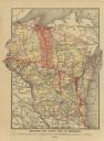
| Date: | 1889 |
|---|---|
| Description: | A map that shows the railroad's lines in Wisconsin, northern Illinois, and the Upper Peninsula of Michigan. Those that are marked with a red line are those... |

| Date: | 1847 |
|---|---|
| Description: | A hand-colored map that shows the area south and east of the Wisconsin and Fox Rivers, as well as a few landmarks just north of that area. The township gri... |

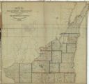
| Date: | 1851 |
|---|---|
| Description: | A survey map of Wisconsin and eastern Minnesota, with the township surveys for portions of the Saint Croix region in progress. The maps also show the Meno... |

| Date: | 1916 |
|---|---|
| Description: | In 1916, it was estimated that 15,000 Indian mounds had formerly existed in Wisconsin. In the early 20th century, the Wisconsin Archaeological Society surv... |

| Date: | 1837 |
|---|---|
| Description: | This map shows the townships, roads, trails, natural land forms, vegetation, mill sites and lead and copper deposits in the Wisconsin Territory at the time... |

| Date: | 1837 |
|---|---|
| Description: | Map of Lake Winnebago and the area south of the Fox River from Green Bay to Sheboygan. The map is oriented with North to the right. |

| Date: | 1838 |
|---|---|
| Description: | This manuscript map, drawn in pencil, shows the lakes and rivers in the area between Lake of the Woods in northern Minnesota, the Mississippi River on the ... |
| Date: | 1837 |
|---|---|
| Description: | This map shows the townships, counties, prairies, and swamps in the Wisconsin Territory at the time. It includes the land south of the Wisconsin and Fox Ri... |

| Date: | 1839 |
|---|---|
| Description: | Wisconsin was considered part of Michigan Territory until 1836, a year before Michigan entered statehood. Drawn in 1839, this map shows the state of Michig... |

| Date: | 1844 |
|---|---|
| Description: | Wisconsin was considered part of Michigan Territory until 1836, a year before Michigan entered statehood. Drawn four years before Wisconsin entered stateho... |
If you didn't find the material you searched for, our Library Reference Staff can help.
Call our reference desk at 608-264-6535 or email us at: