 Filter: Categories of Wisconsin Historical Images
Filter: Subject of Medicine
Filter: Type of Map or Atlas
Filter: Subject of rivers
Filter: Subject of hospitals
Filter: Categories of Wisconsin Historical Images
Filter: Subject of Medicine
Filter: Type of Map or Atlas
Filter: Subject of rivers
Filter: Subject of hospitals

| Date: | 1919 |
|---|---|
| Description: | This is a collection of three hand-colored plat maps. One map is a plat plan and includes annotations and an index that shows public land, business, indust... |
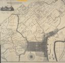
| Date: | |
|---|---|
| Description: | Detail of Philadelphia including an illustration of the Pennsylvania Hospital and the Schuykill River. |

| Date: | 1976 |
|---|---|
| Description: | A street map of Milwaukee County, Wisconsin that identifies the location of schools, hospitals, parks, beaches, streets, freeways, both planned or under co... |

| Date: | 1990 |
|---|---|
| Description: | This late 20th century tourist map of Sauk County, Wisconsin, shows the highways and roads, cities and towns, parks, airports, canoe landings, hospitals, s... |

| Date: | 1831 |
|---|---|
| Description: | Map of the city of Louisville, Kentucky on the Ohio River showing streets and numbered lots. The Ohio River, Corn Island, and the Louisville and Portland C... |

| Date: | 1834 |
|---|---|
| Description: | This map is pen, ink, and pencil on paper and shows plat of the town, local streets, mills, forts, hospitals, and parts of Devil River and Fox River. |

| Date: | 04 1905 |
|---|---|
| Description: | Map of the Madison, Wisconsin region showing the four major lakes, starting in the north with Lake Mendota, Lake Monona, Lake Waubesa, and Lake Kegonsa. La... |

| Date: | 1893 |
|---|---|
| Description: | This map shows wards, railroads, street cars, streets, lot and block numbers, landownership, parks, hospitals, the Sheboygan River, and Lake Michigan. Ward... |

| Date: | 1879 |
|---|---|
| Description: | This map shows asylums, cemeteries, hospitals, parks, streets, and wards. Relief is shown by contours. Also included are manuscript annotations in pencil. ... |

| Date: | 1921 |
|---|---|
| Description: | This map shows various zones in a proposed city ordinance. Also shown are creeks, streets, parks, hospitals, cemeteries, and the Fox River. A legend is inc... |

| Date: | 1960 |
|---|---|
| Description: | This map shows U.S. highways, state highways, county highways, town roads, county parks, county highway buildings, waysides, rivers, lakes, airports, a civ... |

| Date: | 1904 |
|---|---|
| Description: | Map showing lots, additions, and wards within the city limits, as well as some landownership. The streets are labeled, as is Lake Winnebago, rivers, railro... |

| Date: | 1760 |
|---|---|
| Description: | Map showing upstate New York, Lake Ontario, and the St. Lawrence River during the last, decisive battle of the French and Indian War. The main map shows a ... |

| Date: | 1789 |
|---|---|
| Description: | Map of New York City showing ward boundaries, ferries, streets, roads, swamps, ponds, and rivers. The properties of Lispinard, Byards, Jones, Rutgers, and ... |
If you didn't find the material you searched for, our Library Reference Staff can help.
Call our reference desk at 608-264-6535 or email us at: