 Filter: Categories of Wisconsin Historical Images
Filter: Subject of Marshes
Filter: Categories of Wisconsin Historical Images
Filter: Subject of Marshes

| Date: | 1840 |
|---|---|
| Description: | This map surveyed under the direction of Captain Thomas J. Cram is one in a series of seventeen that accompanied Cram's report on the Fox-Wisconsin river s... |

| Date: | 1960 |
|---|---|
| Description: | View of Ennis Lake, also known as Fountain Lake, located in the John Muir Memorial Park near Montello. As a boy, John Muir lived with his family on the sho... |

| Date: | 1960 |
|---|---|
| Description: | View of Ennis Lake, also known as Fountain Lake, located in the John Muir Memorial Park near Montello. As a boy, John Muir lived with his family on the sho... |
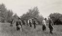
| Date: | |
|---|---|
| Description: | Six-man crew at Camp Mercer looking for ribes (gooseberries), a stage essential for the transmission of blister rust to white pines, working in a marsh are... |

| Date: | 1925 |
|---|---|
| Description: | The Pierre Pauquette monument located at the easterm terminus of the Wauona Trail. Erected by the Wau-bun Chapter of the Daughters of the American Revoluti... |
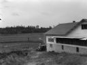
| Date: | 09 1934 |
|---|---|
| Description: | View of a cranberry marsh and warehouse. In the foreground is a warehouse for the storage of harvested cranberries. |

| Date: | 1905 |
|---|---|
| Description: | View of town behind a prairie field and a lake. Caption reads: "Packwaukee, Wis." |

| Date: | |
|---|---|
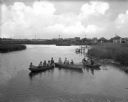
| Description: | At Big Muskegan Wind. In a marsh part of a lake, a man in waders is bent over among the reeds. In the background are three people in a boat, with one perso... |

| Date: | |
|---|---|
| Description: | A man wearing a hat, possibly Ho-Chunk, is mounted bareback on a horse knee-deep in water in a marsh. |
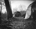
| Date: | |
|---|---|
| Description: | Ho-Chunk lodges among trees. Probably a Ho-Chunk encampment at the cranberry marsh. |

| Date: | |
|---|---|
| Description: | Ho-Chunk winter lodges among trees, probably a Ho-Chunk encampment at the cranberry marsh. There are large, cut logs in between two lodges. A small Ho-Chun... |
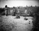
| Date: | |
|---|---|
| Description: | Standing together in a row are two Ho-Chunk girls wearing print dresses, and two Ho-Chunk boys who are nude on a sandy pile in front of a marsh. In front o... |
| Date: | |
|---|---|
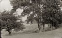
| Description: | A hunter is standing beneath large trees near a marsh holding a rifle. |

| Date: | |
|---|---|
| Description: | A peaceful view of a pond and mill, featuring a small dog sitting in a boat, which rests on the shore. |
| Date: | |
|---|---|
| Description: | Elevated view of a group of children, infants, and adults sitting in rowboats in the water at Manasquan Beach. In the background are rows of dwellings, and... |

| Date: | 1972 |
|---|---|
| Description: | This map on 5 sheets features a title page sheet with business directory and shows section numbers, roads, railroads, saw mills, churches, blacksmith shops... |

| Date: | 1847 |
|---|---|
| Description: | A hand-colored map that shows the area south and east of the Wisconsin and Fox Rivers, as well as a few landmarks just north of that area. The township gri... |

| Date: | 1839 |
|---|---|
| Description: | This map shows the township and section grid, lakes, rivers, swamps, prairies, roads, and proposed canals in the area of Wisconsin south of Lake Winnebago ... |

| Date: | 1840 |
|---|---|
| Description: | This hand-colored map shows the township and section grid in southeastern Wisconsin, covering the area west to Sugar River and Four Lakes region and north ... |

| Date: | 1855 |
|---|---|
| Description: | This map shows the township survey grid and identifies counties, named towns, rivers, lakes, railroads, and proposed railroads,. Horicon Marsh is labeled H... |
If you didn't find the material you searched for, our Library Reference Staff can help.
Call our reference desk at 608-264-6535 or email us at: