 Filter: Categories of Wisconsin Historical Images
Filter: Subject of Marshes
Filter: Subject of political science
Filter: Categories of Wisconsin Historical Images
Filter: Subject of Marshes
Filter: Subject of political science

| Date: | 01 17 1980 |
|---|---|
| Description: | Vel Phillips standing outdoors wearing a coat holding binoculars. |

| Date: | 01 17 1980 |
|---|---|
| Description: | Group portrait at Horicon Marsh. Vel Phillips stands in the middle of the group wearing a coat and dark pants. The man on the far right is W. Dale Phillips... |

| Date: | 1755 |
|---|---|
| Description: | This map shows the eastern half of North America during the French and Indian war, including cities, borders, Native American Land, forts, and detailed geo... |

| Date: | 1770 |
|---|---|
| Description: | Map of North America from the Great Lakes to the northern portion of South America. It shows cities, Native American land, mountains, swamps, lakes, rivers... |

| Date: | 1782 |
|---|---|
| Description: | Map of America covering the Rio Grande to the Atlantic Ocean, showing boundaries, the colonies, cities, settlements, Native American lands and villages, m... |
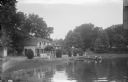
| Date: | |
|---|---|
| Description: | View across water towards a section of Sandy Beach Resort. There are people on the lawn on the left next to buildings. Two women are talking on a porch in ... |
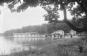
| Date: | |
|---|---|
| Description: | View from shoreline of Sandy Beach Resort. The building near the pier on the left has a sign on the roof for the resort. Along the shoreline are buildings,... |
If you didn't find the material you searched for, our Library Reference Staff can help.
Call our reference desk at 608-264-6535 or email us at: