 Filter: Categories of Wisconsin Historical Images
Filter: Subject of Marshes
Filter: Subject of land use, rural
Filter: Categories of Wisconsin Historical Images
Filter: Subject of Marshes
Filter: Subject of land use, rural
| Date: | 1900 |
|---|---|
| Description: | A woman stands in a marsh near the site of Eleazer William's first house. |
| Date: | |
|---|---|
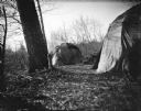
| Description: | Ho-Chunk lodges among trees. Probably a Ho-Chunk encampment at the cranberry marsh. |

| Date: | |
|---|---|
| Description: | Standing together in a row are two Ho-Chunk girls wearing print dresses, and two Ho-Chunk boys who are nude on a sandy pile in front of a marsh. In front o... |
| Date: | |
|---|---|
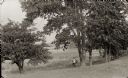
| Description: | A hunter is standing beneath large trees near a marsh holding a rifle. |
| Date: | 09 08 1914 |
|---|---|
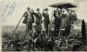
| Description: | Five men in hats and jackets, some holding the levers on a gang plow pulled by a Rumley tractor, pose for a group portrait. One man in work clothes stands ... |

| Date: | 1914 |
|---|---|
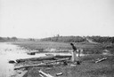
| Description: | View of a drainage ditch in Horicon Marsh. A man is on a path along the left of the ditch. |
| Date: | 1914 |
|---|---|
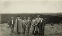
| Description: | Group of well-dressed men standing in front of a plowed segment of Horicon Marsh. |

| Date: | 10 1914 |
|---|---|
| Description: | View of furrowed ground in Horicon Marsh and men on a tractor in the process of plowing a drained portion of the marsh. |
| Date: | |
|---|---|
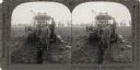
| Description: | Stereograph showing workers digging a ditch with a tractor and laying drain tile. |

| Date: | 1934 |
|---|---|
| Description: | This map shows the area as it appeared in 1848 and includes buildings, land use, and roads with distances to nearby locations. The upper right corner reads... |

| Date: | 06 30 1895 |
|---|---|
| Description: | A man is standing in the right foreground near a tall plant, perhaps corn. In the center is a square-shaped pond with high banks. A man is in the backgroun... |

| Date: | 1776 |
|---|---|
| Description: | Fairly detailed map of New York City and parts of Long Island. It shows streets, roads, wharves, ferries, ship yards, Fort George and the battery, public b... |

| Date: | 1755 |
|---|---|
| Description: | Map of Virginia and parts of Maryland, North Carolina, and New Jersey. It shows borders, boundary lines, some Native American land, counties, cities, towns... |

| Date: | 1776 |
|---|---|
| Description: | Map of Virginia and parts of Maryland and Delaware (written "De La War"). It shows borders, counties, cities, towns, plantations (marked by landowners name... |
If you didn't find the material you searched for, our Library Reference Staff can help.
Call our reference desk at 608-264-6535 or email us at: