 Filter: Categories of Wisconsin Historical Images
Filter: Subject of Marshes
Filter: Subject of human settlements
Filter: Community of Madison
Filter: Categories of Wisconsin Historical Images
Filter: Subject of Marshes
Filter: Subject of human settlements
Filter: Community of Madison

| Date: | 1904 |
|---|---|
| Description: | Monona Bay from the railroad trestle looking southwest, close to where the railroad tracks cross North Shore Drive, (now Brittingham Park), with old houses... |
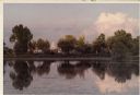
| Date: | 1900 |
|---|---|
| Description: | Wetland, grassy pasture, ring fence are part of the College of Agriculture Farm on the University of Wisconsin Madison campus. |

| Date: | 1906 |
|---|---|
| Description: | Shacks at the foot of North Main Street along Lake Monona near what later became Brittingham Park. |

| Date: | 1910 |
|---|---|
| Description: | Shows existing and proposed parks, railroads, and marshes in a color coded key. "Contour interval 20 feet." Lake Wingra, Lake Mendota, and Lake Monona are ... |

| Date: | 1871 |
|---|---|
| Description: | This map shows buildings, roads, the railroad, an orchard, and swamp land. Relief shown by hachures. The map includes an index of buildings in the upper ri... |

| Date: | |
|---|---|
| Description: | View of Johnson duck shack at old Cherokee Marsh amidst trees and shrubs. The site was where plans for the Ducks Unlimited southern Wisconsin chapter were ... |
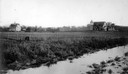
| Date: | |
|---|---|
| Description: | View of Madison from a marsh on the west end of the University of Wisconsin campus. |
If you didn't find the material you searched for, our Library Reference Staff can help.
Call our reference desk at 608-264-6535 or email us at: