 Filter: Categories of Wisconsin Historical Images
Filter: Subject of Marshes
Filter: Subject of human settlements
Filter: Creator Name of Unknown
Filter: Categories of Wisconsin Historical Images
Filter: Subject of Marshes
Filter: Subject of human settlements
Filter: Creator Name of Unknown

| Date: | 1898 |
|---|---|
| Description: | Caption reads: "Old Stone Tower and House, Long Tail Point, Green Bay, Wis." Water and a marshy area are in the foreground. |

| Date: | 1905 |
|---|---|
| Description: | Long Tail Lighthouse and surrounding buildings. |
| Date: | 1907 |
|---|---|
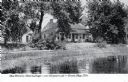
| Description: | View across water toward the Tank Cottage. Caption reads: "The Historic Tank Cottage — over 100 years old — Green Bay, Wis." |
| Date: | 1945 |
|---|---|
| Description: | View of the Wausau Memorial Hospital, with the Wisconsin River in the foreground. |

| Date: | 1905 |
|---|---|
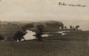
| Description: | View of town behind a prairie field and a lake. Caption reads: "Packwaukee, Wis." |

| Date: | 1934 |
|---|---|
| Description: | This map shows the area as it appeared in 1848 and includes buildings, land use, and roads with distances to nearby locations. The upper right corner reads... |

| Date: | 1789 |
|---|---|
| Description: | Map of New York City showing ward boundaries, ferries, streets, roads, swamps, ponds, and rivers. The properties of Lispinard, Byards, Jones, Rutgers, and ... |

| Date: | 1776 |
|---|---|
| Description: | Fairly detailed map of New York City and parts of Long Island. It shows streets, roads, wharves, ferries, ship yards, Fort George and the battery, public b... |

| Date: | 1779 |
|---|---|
| Description: | Map of North Carolina showing counties, cities, towns, chapels, courthouses, Quaker meeting houses, forts, mountains, swamps, inlets, lakes, and rivers. A ... |

| Date: | 1779 |
|---|---|
| Description: | Map of South Carolina showing boundary lines, Native American land, precincts, townships, cities, towns, forts, roads, mountains, hills, swamps, islands, a... |

| Date: | 1779 |
|---|---|
| Description: | Map of colonial Georgia showing cities, towns, Native American land and towns, forts, roads, trading paths, islands, mountains, swamps, and rivers. Annotat... |

| Date: | 1765 |
|---|---|
| Description: | Map showing the new British territories of East and West Florida following the Treaty of Paris at the end of the French and Indian War. It shows boundaries... |

| Date: | 1761 |
|---|---|
| Description: | Map covering southern Louisiana from Lake Ponchetrain to the Golf of Mexico and from Woods Bay in the west to the islands just east of Bay St. Louis. It sh... |
| Date: | |
|---|---|
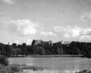
| Description: | View of Lake Waubesa from a hill. A farm is in the distance on the left. The Yahara River is in the foreground. Handwritten caption reads: "Lake Waubesa." |
| Date: | 1907 |
|---|---|
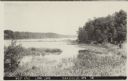
| Description: | Text on front reads: "West End, Long Lake, Saxeville, Wis." View of a lake with marshland plants in the foreground. A dock, boat and trees are on the right... |
If you didn't find the material you searched for, our Library Reference Staff can help.
Call our reference desk at 608-264-6535 or email us at: