Filter: Categories of Wisconsin Historical Images
Filter: Subject of Maps
Filter: Categories of Wisconsin Historical Images
Filter: Subject of Maps
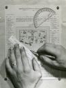
| Date: | |
|---|---|
| Description: | Person's hands, one with with wedding ring on left hand, using a ruler, pencil, and protractor to draw a land cover map for Wisconsin Land Economic Invento... |

| Date: | 1917 |
|---|---|
| Description: | The Lake Forest community plan, a model community that was planned for the site where the University of Wisconsin Arboretum now stands. |
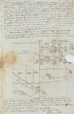
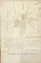
| Date: | 11 26 1846 |
|---|---|
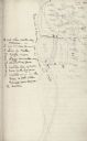
| Description: | A drawing by Thomas Steel of his farm property contained in a letter Steel wrote to his father James Steel. |

| Date: | 04 13 1944 |
|---|---|
| Description: | Mrs. Walter S. Goodland, Wisconsin's First Lady, R.C. Tomlinson, USO Club new director, and Mrs. Tomlinson, guests of honor at a tea held at the USO Club. ... |

| Date: | 1933 |
|---|---|
| Description: | Map created by International Harvester entitled: "The United States as it appeared in 1831 when Cyrus Hall McCormick invented the Reaper." The map pinpoint... |
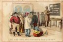
| Date: | 1899 |
|---|---|
| Description: | Back cover of an advertising catalog for D.M. Osborne and Company showing a schoolmaster in front of men from many nations. Includes the caption "all natio... |

| Date: | 1925 |
|---|---|
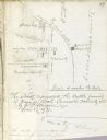
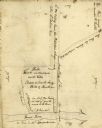
| Description: | A map of the farm planned by Edwin Bottomley in 1844. |
| Date: | |
|---|---|
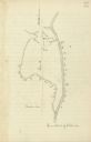
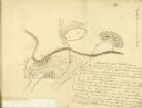
| Description: | Drawn map of the Catawba River, fishing creek, and surrounding landscape from the Sumter Papers. |
| Date: | |
|---|---|
| Description: | Drawn map of Landsford, South Carolina, from Thomas Sumter Papers. |
| Date: | |
|---|---|
| Description: | Drawn map of the Hanging Rock Battlefield in the Thomas Sumter Papers. |
| Date: | |
|---|---|
| Description: | Drawn map of Hanging Rock Battlefield from the Thomas Sumter Papers. |
| Date: | |
|---|---|
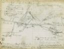
| Description: | Drawn map of Blackstock's Plantation battlefield from the Sumter Papers. |
| Date: | |
|---|---|
| Description: | Drawn map of the Fish Damn Ford battlefield from the Thomas Sumter Papers. |
| Date: | |
|---|---|
| Description: | Drawn map of Blackstock's Plantation battlefield from the Thomas Sumter Papers. |

| Date: | 08 01 1944 |
|---|---|
| Description: | Two workers at the United State Armed Forces Institute are: Robert Halverson and John Barr, recently in the armed services and participants in the educatio... |
| Date: | 08 09 1944 |
|---|---|
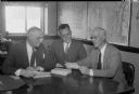
| Description: | James R. Law, chairman of the Dane County Chapter of the National Foundation for Infantile Paralysis, Palmer F. Daugs, Lake Mills, representative of the Na... |
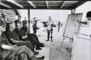
| Date: | 1971 |
|---|---|
| Description: | Secretary of Defense Melvin Laird, and several cigar-smoking officers are listening to a presentation about the war in Vietnam. |

| Date: | 09 15 1944 |
|---|---|
| Description: | Phyllis Wiswell, student at Central High School, compares a Wisconsin State Journal map with a classroom map to get a more complete picture of current even... |

| Date: | 11 10 1944 |
|---|---|
| Description: | Mayor F. Halsey Kraege standing in front of a 1930 City of Madison map. |
If you didn't find the material you searched for, our Library Reference Staff can help.
Call our reference desk at 608-264-6535 or email us at: