 Filter: Categories of Wisconsin Historical Images
Filter: Subject of Maps
Filter: Year of 1900-1999
Filter: Categories of Wisconsin Historical Images
Filter: Subject of Maps
Filter: Year of 1900-1999
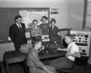
| Date: | 10 31 1952 |
|---|---|
| Description: | Two members of the West High School radio club, Alan Frees and Bill Reeve, operating the club's "ham" station. Observing the young men are Henry Lugg, spo... |

| Date: | 1920 |
|---|---|
| Description: | Calumet Harbor on Lake Winnebago. On the left is a map, and on the right are two images, one captioned: "Calumet Harbor". |

| Date: | 1910 |
|---|---|
| Description: | Aerial view of some of the 26 lakes known collectively as the Chain O' Lakes. Caption reads: "Aeroplane View of Chain O'Lakes, Waupaca, Wis." |
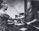
| Date: | 1971 |
|---|---|
| Description: | Secretary of Defense Melvin Laird, wearing a fatigue uniform, shaking hands with a military officer during a tour of Vietnam. |

| Date: | 1910 |
|---|---|
| Description: | Advertising poster for Osborne brand agricultural equipment produced by International Harvester for Russia. Features a map of Russia with inset color illus... |

| Date: | 1910 |
|---|---|
| Description: | Advertising poster for Plano brand agricultural machinery produced by International Harvester for Russia. Features a map of Russia with inset color illustr... |

| Date: | 1917 |
|---|---|
| Description: | The Lake Forest community plan, a model community that was planned for the site where the University of Wisconsin Arboretum now stands. |

| Date: | 04 13 1944 |
|---|---|
| Description: | Mrs. Walter S. Goodland, Wisconsin's First Lady, R.C. Tomlinson, USO Club new director, and Mrs. Tomlinson, guests of honor at a tea held at the USO Club. ... |

| Date: | 1933 |
|---|---|
| Description: | Map created by International Harvester entitled: "The United States as it appeared in 1831 when Cyrus Hall McCormick invented the Reaper." The map pinpoint... |

| Date: | 1925 |
|---|---|
| Description: | A map of the farm planned by Edwin Bottomley in 1844. |

| Date: | 08 01 1944 |
|---|---|
| Description: | Two workers at the United State Armed Forces Institute are: Robert Halverson and John Barr, recently in the armed services and participants in the educatio... |
| Date: | 08 09 1944 |
|---|---|
| Description: | James R. Law, chairman of the Dane County Chapter of the National Foundation for Infantile Paralysis, Palmer F. Daugs, Lake Mills, representative of the Na... |
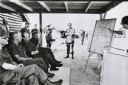
| Date: | 1971 |
|---|---|
| Description: | Secretary of Defense Melvin Laird, and several cigar-smoking officers are listening to a presentation about the war in Vietnam. |

| Date: | 09 15 1944 |
|---|---|
| Description: | Phyllis Wiswell, student at Central High School, compares a Wisconsin State Journal map with a classroom map to get a more complete picture of current even... |
| Date: | 11 10 1944 |
|---|---|
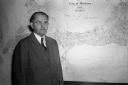
| Description: | Mayor F. Halsey Kraege standing in front of a 1930 City of Madison map. |

| Date: | 1924 |
|---|---|
| Description: | Front and back covers of Scenic Wisconsin Motorways, a guide to Wisconsin roads compiled by Victor F. Pettric and published by the Wisconsin Motorists Asso... |

| Date: | 1904 |
|---|---|
| Description: | A map showing the design for a park fronting on Lake Monona Bay. (Now called Brittingham Park) taken from between pages 44 & 45 of the 1905 Madison Park a... |
| Date: | 06 08 1945 |
|---|---|
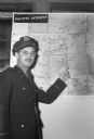
| Description: | Marine Robert M. Crabb pointing to Japan on a map. He was home in Madison after serving as a war correspondent and being a prisoner of war for three years ... |
| Date: | 07 02 1945 |
|---|---|
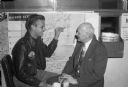
| Description: | First Lieut. Robert V. Merklein is showing his father, O.F. Merklein, the location of Yokohama, where he downed his first Japanese plane. |
| Date: | 1943 |
|---|---|
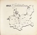
| Description: | Map of Concentration Camps in Germany, titled "1943 31 Zuchtstationen," where the SS kept angora rabbits for their wool raising projects at concentration c... |
If you didn't find the material you searched for, our Library Reference Staff can help.
Call our reference desk at 608-264-6535 or email us at: